Secret nuclear bunker
Introduction
The photograph on this page of Secret nuclear bunker by Tiger as part of the Geograph project.
The Geograph project started in 2005 with the aim of publishing, organising and preserving representative images for every square kilometre of Great Britain, Ireland and the Isle of Man.

There are currently over 7.5m images from over 14,400 individuals and you can help contribute to the project by visiting https://www.geograph.org.uk
Secret nuclear bunker
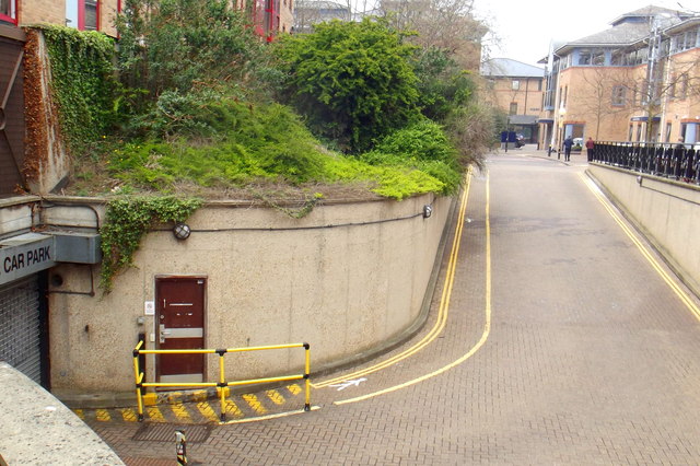
Image: © Tiger Taken: 8 Apr 2019
A secret no longer, as it has been featured in the local press and even opened its unassuming door (behind the yellow railings) to visitors during Heritage Open Days. Concealed beneath the former Castle Court offices on the Shire Hall site and covered by a living roof, the bunker would have provided a safe refuge for council officers to coordinate responses to any nuclear incident affecting the area. Protected by an airlock and two blast doors, it provides working space and living accommodation for up to 40 personnel. There is a communications suite to enable enquiries from the public to be answered and information and advice to be broadcast to the local population. It has its own independent power supply and reserves of fuel and water to permit it to operate off grid. Over the years the facility has been used not only for civil defence training exercises but as a call centre in response to local flooding and other emergency incidents. It now provides archive storage for the County Council's archaeology unit. https://www.cambridge-news.co.uk/news/cambridge-news/gallery/shire-halls-secret-nuclear-bunker-13824512
Images are licensed for reuse under creativecommons.org/licenses/by-sa/2.0
Image Location
Latitude
52.213601
Longitude
0.113729