IMAGES TAKEN NEAR TO
Barkways, CAMBRIDGE, CB25 0RG
Introduction
This page details the photographs taken nearby to Barkways, CB25 0RG by members of the Geograph project.
The Geograph project started in 2005 with the aim of publishing, organising and preserving representative images for every square kilometre of Great Britain, Ireland and the Isle of Man.

There are currently over 7.5m images from over14,400 individuals and you can help contribute to the project by visiting https://www.geograph.org.uk
Image Map
Images are licensed for reuse under creativecommons.org/licenses/by-sa/2.0
Notes
- Clicking on the map will re-center to the selected point.
- The higher the marker number, the further away the image location is from the centre of the postcode.
Image Listing (8 Images Found)
Images are licensed for reuse under creativecommons.org/licenses/by-sa/2.0
Image
Details
Distance
1
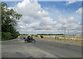
Burwell: a building site on Newmarket Road
The motorcyclist is turning out of Isaacson Road. Houses are to be built on this large greenfield site and according to the publicity 75% of them will be unaffordable.
Image: © John Sutton
Taken: 4 Aug 2022
0.07 miles
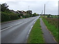
2
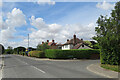
Newmarket Road Burwell
Looking South East along Newmarket Road Burwell. Cambridgeshire.
Image: © Keith Evans
Taken: 22 Aug 2017
0.08 miles
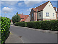
3
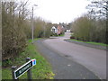
Burwell: Isaacson Road
A suburban-looking part of a large village on the edge of the Cambridgeshire Fens. Copperfield Way is on the right.
Image: © John Sutton
Taken: 4 Aug 2022
0.10 miles
4
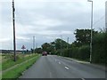
Newmarket Road, Burwell (B1103)
Looking north west.
Image: © JThomas
Taken: 15 Oct 2015
0.10 miles
7
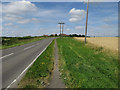
Path by B1103
Looking towards Burwell.
Image: © Hugh Venables
Taken: 24 Jul 2016
0.16 miles