IMAGES TAKEN NEAR TO
Field View, CAMBRIDGE, CB25 0FQ
Introduction
This page details the photographs taken nearby to Field View, CB25 0FQ by members of the Geograph project.
The Geograph project started in 2005 with the aim of publishing, organising and preserving representative images for every square kilometre of Great Britain, Ireland and the Isle of Man.

There are currently over 7.5m images from over14,400 individuals and you can help contribute to the project by visiting https://www.geograph.org.uk
Image Map
Images are licensed for reuse under creativecommons.org/licenses/by-sa/2.0
Notes
- Clicking on the map will re-center to the selected point.
- The higher the marker number, the further away the image location is from the centre of the postcode.
Image Listing (12 Images Found)
Images are licensed for reuse under creativecommons.org/licenses/by-sa/2.0
Image
Details
Distance
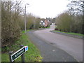
1
Path by B1103
Looking towards Burwell.
Image: © Hugh Venables
Taken: 24 Jul 2016
0.13 miles
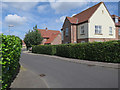
2
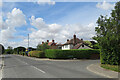
Burwell: Isaacson Road
A suburban-looking part of a large village on the edge of the Cambridgeshire Fens. Copperfield Way is on the right.
Image: © John Sutton
Taken: 4 Aug 2022
0.15 miles
3
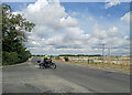
Burwell: a building site on Newmarket Road
The motorcyclist is turning out of Isaacson Road. Houses are to be built on this large greenfield site and according to the publicity 75% of them will be unaffordable.
Image: © John Sutton
Taken: 4 Aug 2022
0.15 miles
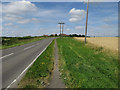
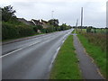
4
Newmarket Road Burwell
Looking South East along Newmarket Road Burwell. Cambridgeshire.
Image: © Keith Evans
Taken: 22 Aug 2017
0.16 miles
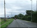
6
Newmarket Road, Burwell (B1103)
Looking north west.
Image: © JThomas
Taken: 15 Oct 2015
0.18 miles
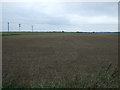
8
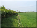
The western border of Suffolk, Exning
The camera is at the most westerly point in Suffolk looking along the Suffolk\Cambridgeshire boundary which runs along edge of this field. The hedgerow is on a raised bank, which indicates an ancient boundary: The county line, which is also the boundary of the parish of Exning, is jagged following old field patterns.
The local parish church website http://www.exningparishchurch.net/history_village.htm gives this explanation as to why Exning was not incorporated in Cambridgeshire:
"If you look at the modern map of East Anglia, you will notice that the bulge of West Suffolk into Cambridgeshire consists of the ancient parish of Exning. Why was it that Exning was not incorporated in Cambridgeshire? The reason given was the ancient name and fame of Exning from the past; so it was allowed to remain in East Anglia because Cambridge was not East Anglia in the real sense of the word."
Image: © Roger Jones
Taken: 4 May 2014
0.19 miles
9

Exning Road Halt
Exning Road Halt on the Cambridge & Mildenhall branch line was opened in November 1922, and closed in 1962. The halt was not much more than a levelled space, with no raised platform or buildings of any kind; it was situated to the south of the bridge carrying the B1103 Burwell – Newmarket road, and to the east of the line. Access was by a footpath down the side of the bridge approach. The bridge was found to be dangerous, and was filled in c.2000.
The picture is from the top of the bridge, looking south along the old trackbed, the halt was in the grassed area to the left of the picture.
Image: © Tony Lewis
Taken: 19 Aug 2008
0.19 miles