IMAGES TAKEN NEAR TO
Dry Drayton Road, CAMBRIDGE, CB24 3YX
Introduction
This page details the photographs taken nearby to Dry Drayton Road, CB24 3YX by members of the Geograph project.
The Geograph project started in 2005 with the aim of publishing, organising and preserving representative images for every square kilometre of Great Britain, Ireland and the Isle of Man.

There are currently over 7.5m images from over14,400 individuals and you can help contribute to the project by visiting https://www.geograph.org.uk
Image Map
Images are licensed for reuse under creativecommons.org/licenses/by-sa/2.0
Notes
- Clicking on the map will re-center to the selected point.
- The higher the marker number, the further away the image location is from the centre of the postcode.
Image Listing (10 Images Found)
Images are licensed for reuse under creativecommons.org/licenses/by-sa/2.0
Image
Details
Distance
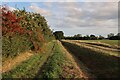
2
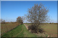
Ploughland near Oakington
Oakington Business Park, the former Phypers Farm, is on the extreme left of this winter-morning view from the Dry Drayton Road end of a bridle path to Longstanton.
Image: © John Sutton
Taken: 28 Jan 2016
0.08 miles
3
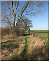
Bridleway and bridge
This bridleway - this part of which is not marked on current 1:50,000 maps - runs from Dry Drayton Road (behind the camera) to Longstanton. The bridge rails look quite new.
Image: © John Sutton
Taken: 28 Jan 2016
0.11 miles
4
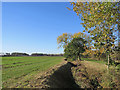
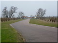
Towards the A14
Traffic will be slow-moving hereabouts until the completion of the A14 improvements in 2020. The A14 marks the edge of The Fens: dykes and flat fields on this side (and Fen Drayton and Fenstanton), the gentle hills of west Cambridgeshire (and Dry Drayton) on the other.
Image: © John Sutton
Taken: 2 Nov 2018
0.13 miles
5
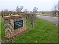
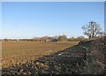
Entrance to Oakington Business Park
The entrance to Oakington Business Park is seen from Dry Drayton Road just before Oakington is reached. This was a bitterly cold February day with an icy wind. The business park is on what was marked as Phypers Farm on the map, but has a new entrance road as seen here.
Image: © Marathon
Taken: 23 Feb 2013
0.21 miles
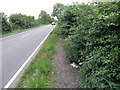
6
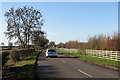
On Dry Drayton Road
A stationary cyclist's view towards the A14 and Dry Drayton on the road from Oakington. The entrance to Oakington Business Park is a little way ahead, on the right.
Image: © John Sutton
Taken: 28 Jan 2016
0.22 miles
7
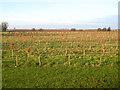
Beech plantation, Oakington, Cambs
– view of neatly planted rows NW of the Dry Drayton Road.
Image: © Rodney Burton
Taken: 10 Dec 2005
0.23 miles
8
Road to Oakington Business Park
The road to Oakington Business Park is seen from Dry Drayton Road just before Oakington is reached. This was a bitterly cold February day with an icy wind. The business park is on what was marked as Phypers Farm on the map, but has a new access as seen here.
Image: © Marathon
Taken: 23 Feb 2013
0.23 miles
9
Bridleway to Dry Drayton Road
Linking to the road, despite what the map shows, see Image
Image: © Hugh Venables
Taken: 26 Sep 2023
0.23 miles
10
Path finding on the Pathfinder near Oakington
Walking towards the A14 and on to Dry Drayton on a section of the Pathfinder long distance footpath. The path fizzles out near to the A14 so you have to be very careful as there is no reasonable alternative for walking other than on the road or rough verge.
Image: © Michael Trolove
Taken: 18 May 2011
0.24 miles