IMAGES TAKEN NEAR TO
Station Road, CAMBRIDGE, CB24 3DR
Introduction
This page details the photographs taken nearby to Station Road, CB24 3DR by members of the Geograph project.
The Geograph project started in 2005 with the aim of publishing, organising and preserving representative images for every square kilometre of Great Britain, Ireland and the Isle of Man.

There are currently over 7.5m images from over14,400 individuals and you can help contribute to the project by visiting https://www.geograph.org.uk
Image Map
Images are licensed for reuse under creativecommons.org/licenses/by-sa/2.0
Notes
- Clicking on the map will re-center to the selected point.
- The higher the marker number, the further away the image location is from the centre of the postcode.
Image Listing (190 Images Found)
Images are licensed for reuse under creativecommons.org/licenses/by-sa/2.0
Image
Details
Distance
1
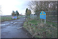
Entrance to Cambridge Golf Club
It is giving every indication that it is shut.
Image: © Bill Boaden
Taken: 30 Jan 2015
0.02 miles
2
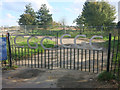
Station Road, Longstanton
This is the approach to Longstanton from the north, just after leaving the new by-pass (B1050), and by the entrance to Cambridge Golf Club. The station which Station Road was named after has long gone. Long Stanton station was just to the north of here away from the village. It was on the Cambridge to March line and closed on 5th October 1970 - see http://www.disused-stations.org.uk/l/long_stanton/ The Cambridge Guided Busway now follows the route at Longstanton - see http://en.wikipedia.org/wiki/Cambridgeshire_Guided_Busway
Image: © Marathon
Taken: 3 May 2013
0.02 miles
3
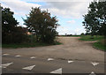
Entrance to Northstowe allotments
Formerly the entrance to Cambridge Golf Club, but the course is now the first phase of Northstowe, with hundreds of houses built on it and the allotments on the driving range. See Image, the ground is slightly higher as spoil from earthworks has been put on the site.
Image: © Hugh Venables
Taken: 8 Sep 2020
0.03 miles
5
Cambridge Golf Club closed
The gates locked as 1500 homes are to be built on the golf course as the first phase of the Northstowe development.
Image: © Hugh Venables
Taken: 1 Nov 2014
0.03 miles
6
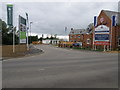
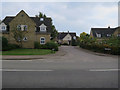
Housing development at Striplands farm
Longstanton is seeing a major housing development to the north of the village.
Image: © Michael Trolove
Taken: 18 May 2011
0.03 miles
7
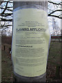
Planning application
Normally these are for minor alterations to nearby buildings. This one is for a whole new town, Northstowe.
Image: © Hugh Venables
Taken: 3 Mar 2012
0.04 miles
8
The village pump
Huge changes around this area. Originally the back drop was Striplands farm, this has all been demolished and is being replaced by a large housing development. Potential purchasers may be put off by the lack of mains water !!
Image: © Michael Trolove
Taken: 18 May 2011
0.04 miles
9
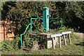
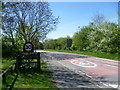
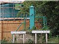
Longstanton pump
This is actually one of two pumps in the village, and is further than would be expected from the centre of the village. I wondered if it had been moved, but old OS maps show there has certainly been a pump at this location since at least 1900. The small shield on the front of the pump below the spout has the inscription "Bamford's frost protected lift pump". This is the firm that is now better known for bright yellow JCB (J C Bamford) excavators. Listed Grade II.
Image: © Alan Murray-Rust
Taken: 28 Sep 2011
0.05 miles
10
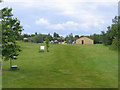
Cambridge Golf Club, Longstanton, Cambs
– view towards the club house.
Image: © Rodney Burton
Taken: 29 May 2006
0.05 miles