IMAGES TAKEN NEAR TO
Damson Way, CAMBRIDGE, CB23 5EJ
Introduction
This page details the photographs taken nearby to Damson Way, CB23 5EJ by members of the Geograph project.
The Geograph project started in 2005 with the aim of publishing, organising and preserving representative images for every square kilometre of Great Britain, Ireland and the Isle of Man.

There are currently over 7.5m images from over14,400 individuals and you can help contribute to the project by visiting https://www.geograph.org.uk
Image Map
Images are licensed for reuse under creativecommons.org/licenses/by-sa/2.0
Notes
- Clicking on the map will re-center to the selected point.
- The higher the marker number, the further away the image location is from the centre of the postcode.
Image Listing (48 Images Found)
Images are licensed for reuse under creativecommons.org/licenses/by-sa/2.0
Image
Details
Distance
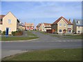
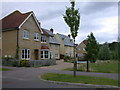
1
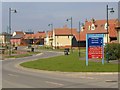
School Lane, Lower Cambourne
A view in which the standard Cambourne streetlights are very much in evidence, and showing one of the development signboards pointing the way to phases which are in the course of construction or sale. I believe the red signs on this board were to show the construction sites and the blue signs the way to the developers sales offices.
Image: © John Brightley
Taken: 13 May 2004
0.04 miles
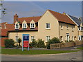
3
Housing at School Lane, Lower Cambourne
An archway in the centre of this terrace of houses leads to the parking courtyard at the rear. Constructed by Wimpey Homes as part of phase LC06.
Image: © John Brightley
Taken: 13 May 2004
0.06 miles
4
House at the corner of School Lane and Quidditch Lane, Lower Cambourne
Built by Wimpey Homes as part of phase LC06.
Image: © John Brightley
Taken: 13 May 2004
0.06 miles
5
Lower Cambourne scene, Cambs
View of homes where Quidditch Lane joins School Lane in the new settlement of Cambourne.
Image: © Rodney Burton
Taken: 23 Mar 2005
0.07 miles
6
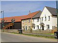
Houses at School Lane, Lower Cambourne
Properties constructed by Bovis Homes as part of phase LC07.
The black timber boarded building on the left is a small flat above a row of garages (which are accessed from the parking court on the other side of the building). This housetype became known in the design office, rather awkwardly I felt, as the 'fog' (flat over garage), and this term was actually adopted by other housebuilders afterwards.
Image: © John Brightley
Taken: 13 May 2004
0.07 miles
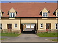
7
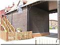
Archway entrance to housing courtyard, School Lane, Lower Cambourne
This barn-style building comprises garages on the ground floor with flats above. The archway gives access to a small courtyard surrounded by houses.
Image: © John Brightley
Taken: 13 May 2004
0.08 miles
8
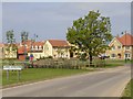
School Lane, Lower Cambourne
The entrance to Lower Cambourne from the east, showing the village name sign. The standard Cambourne streetlights are also very much in evidence.
The new planting in the middle of the photograph is along a bridleway known as Crow Dean (going from left to right in the photo) which existed before the Cambourne development was started.
Image: © John Brightley
Taken: 13 May 2004
0.08 miles
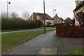
9
Quidditch Lane, Lower Cambourne
Image: © Keith Edkins
Taken: 14 Jul 2008
0.08 miles
10
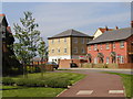
Housing at School Lane, Lower Cambourne
This shows the two Bovis phases LC01 (on the left) and LC07 (on the right). The house just off the photo to the left was firstly a sales centre for these phases and then became the first Bovis Cambridgeshire regional office for a short time before the staff moved to new offices in the High Street.
Image: © John Brightley
Taken: 13 May 2004
0.08 miles