IMAGES TAKEN NEAR TO
Horseheath Road, CAMBRIDGE, CB21 4LU
Introduction
This page details the photographs taken nearby to Horseheath Road, CB21 4LU by members of the Geograph project.
The Geograph project started in 2005 with the aim of publishing, organising and preserving representative images for every square kilometre of Great Britain, Ireland and the Isle of Man.

There are currently over 7.5m images from over14,400 individuals and you can help contribute to the project by visiting https://www.geograph.org.uk
Image Map (Loading...)


Getting Data...Please wait
Leaflet Map data © OpenStreetMap
Images are licensed for reuse under creativecommons.org/licenses/by-sa/2.0
Notes
- Clicking on the map will re-center to the selected point.
- The higher the marker number, the further away the image location is from the centre of the postcode.
Image Listing (28 Images Found)
Images are licensed for reuse under creativecommons.org/licenses/by-sa/2.0
Image
Details
Distance
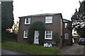
3
Tosca Cottage, Linton
Early C17. Timber-framed and plastered. Thatched roof. Grade II listed.
Image: © Keith Edkins
Taken: 13 Sep 2017
0.03 miles
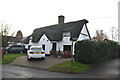
6
Keene Fields
Modern housing in east Linton
Image: © Keith Edkins
Taken: 13 Sep 2017
0.07 miles
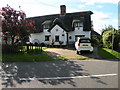
10
![Linton houses [13]](https://s2.geograph.org.uk/geophotos/06/17/09/6170926_a203b909_120x120.jpg)
Linton houses [13]
Formerly a farmhouse, number 18 Bartlow Road is early 17th century timber framed with a 19th century brick casing and rear extension. Listed, grade II, with details at: https://historicengland.org.uk/listing/the-list/list-entry/1331143
Image: © Michael Dibb
Taken: 14 May 2019
0.14 miles