IMAGES TAKEN NEAR TO
Coles Lane, CAMBRIDGE, CB21 4JS
Introduction
This page details the photographs taken nearby to Coles Lane, CB21 4JS by members of the Geograph project.
The Geograph project started in 2005 with the aim of publishing, organising and preserving representative images for every square kilometre of Great Britain, Ireland and the Isle of Man.

There are currently over 7.5m images from over14,400 individuals and you can help contribute to the project by visiting https://www.geograph.org.uk
Image Map (Loading...)


Getting Data...Please wait
Leaflet Map data © OpenStreetMap
Images are licensed for reuse under creativecommons.org/licenses/by-sa/2.0
Notes
- Clicking on the map will re-center to the selected point.
- The higher the marker number, the further away the image location is from the centre of the postcode.
Image Listing (268 Images Found)
Images are licensed for reuse under creativecommons.org/licenses/by-sa/2.0
Image
Details
Distance
2
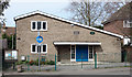
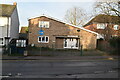
Linton Village Hall
The village hall, on Coles Lane, is used for children's play groups, voting (polling station), meetings, big birthday parties and other social functions. There are small offices for local admin.
Image: © M H Evans
Taken: 10 Apr 2016
0.01 miles
3
![Linton buildings [1]](https://s2.geograph.org.uk/geophotos/06/16/92/6169202_c112f8ed_120x120.jpg)
Linton buildings [1]
The village hall in Coles Lane.
Image: © Michael Dibb
Taken: 14 May 2019
0.01 miles
5
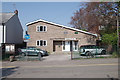
Linton Village Hall
This building, on the west side of Coles Lane, is used for children's play groups, social occasions, meetings and also serves as a voting station during local and national elections. It also houses some offices of the Parish Council.
Image: © M H Evans
Taken: 20 Apr 2018
0.02 miles
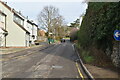
7
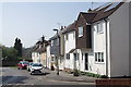
Coles Lane, Linton
Old and modern houses at the southern end of Coles Lane, near the junction with the High Street.
Image: © M H Evans
Taken: 20 Apr 2018
0.03 miles
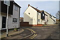
8
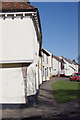
Linton - Coles Lane
The nearest house, "Robert Coles House" is a Grade II* listed building, with a mediaeval 'dragon post' and some pargeting. Several other houses in Coles Lane are also listed.
Image: © M H Evans
Taken: 19 Feb 2016
0.03 miles
9
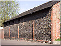
Flint and brick building
Early 19th century building on Linton High Street at the corner of Coles Lane. The flint walling with brick corners and pilasters, and a slate roof, is typical of this region. Possibly built as stables or a storehouse, with only small windows set high above the street. It has recently been in commercial use and the corner has been repaired with modern bricks. The middle brick pilaster (see Image) has a stone set in at the top carved with the date 1812 (see Image).
Image: © M H Evans
Taken: 15 Apr 2012
0.04 miles
10
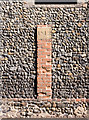
Detail of pilaster
The middle pilaster of the flint-and-brick building on Linton High Street near Coles Lane (see Image). The stone set into the top of the pilaster is elegantly carved with the date: 1812 (see Image).
Image: © M H Evans
Taken: 10 Apr 2012
0.04 miles