IMAGES TAKEN NEAR TO
Budleigh Close, CAMBRIDGE, CB1 3UN
Introduction
This page details the photographs taken nearby to Budleigh Close, CB1 3UN by members of the Geograph project.
The Geograph project started in 2005 with the aim of publishing, organising and preserving representative images for every square kilometre of Great Britain, Ireland and the Isle of Man.

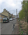
There are currently over 7.5m images from over14,400 individuals and you can help contribute to the project by visiting https://www.geograph.org.uk
Image Map
Images are licensed for reuse under creativecommons.org/licenses/by-sa/2.0
Notes
- Clicking on the map will re-center to the selected point.
- The higher the marker number, the further away the image location is from the centre of the postcode.
Image Listing (162 Images Found)
Images are licensed for reuse under creativecommons.org/licenses/by-sa/2.0
Image
Details
Distance
1
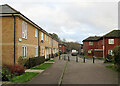
Trefoil Terrace and Budleigh Close
Off Tiverton Way in the estate between Perne Road and Cherry Hinton Brook in suburban Cambridge.
Image: © John Sutton
Taken: 4 Jan 2021
0.03 miles
2
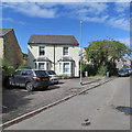
On Burnside in early September
The two small bay-windowed villas, Fern Cottage and Rose Cottage, house a dental practice.
Image: © John Sutton
Taken: 4 Sep 2019
0.04 miles
3
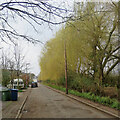
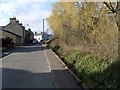
Burnside: signs of spring
Willows are always the first trees to come into leaf at the end of winter, and in the last few days, at the end of the first week of March, their winter yellow has started to shade into green as the leaves unfurl. This row lines the straightened Cherry Hinton Brook.
Image: © John Sutton
Taken: 8 Mar 2021
0.05 miles
4
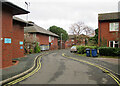
Robert May Close
Off Tiverton Way in the A-Z estate east of Perne Road in the south-eastern suburbs of Cambridge.
Image: © John Sutton
Taken: 4 Jan 2021
0.05 miles
5
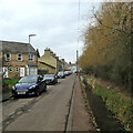
Burnside, Cherry Hinton
Burnside is a street of Victorian terraced houses, with a small, very clean, stream running alongside the road.
Image: © Paul Shreeve
Taken: 5 Mar 2008
0.06 miles
6
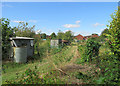
Burnside Allotments
A view over the hedge from Snakey Path. The houses in the distance are on Tiverton Way.
Image: © John Sutton
Taken: 4 Sep 2019
0.07 miles
7
Burnside and Cherry Hinton Brook
The brook is full in the wet winter of 2020-21.
Image: © John Sutton
Taken: 19 Feb 2021
0.07 miles
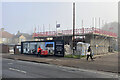
8
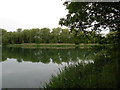
Romsey Lakes
These disused marl pits are normally private property of an angling club. There are plans to open them permanently to the public, and in the meantime there are occasional open days.
Image: © Keith Edkins
Taken: 10 Jun 2018
0.08 miles
9
Burnside and Cherry Hinton Brook
The brook, which rises at Giant's Grave in Cherry Hinton, later becomes Coldham's Brook and joins the Cam at Stourbridge Common.
Image: © John Sutton
Taken: 19 Mar 2017
0.08 miles
10
New houses rising on Perne Road
Two houses replace a demolished bungalow. Image] shows the state of the work two months before.
Image: © John Sutton
Taken: 6 Feb 2023
0.08 miles