IMAGES TAKEN NEAR TO
Station Place, CAMBRIDGE, CB1 2FP
Introduction
This page details the photographs taken nearby to Station Place, CB1 2FP by members of the Geograph project.
The Geograph project started in 2005 with the aim of publishing, organising and preserving representative images for every square kilometre of Great Britain, Ireland and the Isle of Man.

There are currently over 7.5m images from over14,400 individuals and you can help contribute to the project by visiting https://www.geograph.org.uk
Image Map
Images are licensed for reuse under creativecommons.org/licenses/by-sa/2.0
Notes
- Clicking on the map will re-center to the selected point.
- The higher the marker number, the further away the image location is from the centre of the postcode.
Image Listing (1827 Images Found)
Images are licensed for reuse under creativecommons.org/licenses/by-sa/2.0
Image
Details
Distance
1
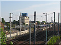
Building next to Cambridge Station
The first steelwork for a new building on the strip of land next to Platform 3 had just gone up.
Image: © John Sutton
Taken: 29 Aug 2013
0.00 miles
2
Cambridge Railway Station: guided bus works
Five days on from Monday's snap http://www.geograph.org.uk/photo/1855354 and the tarmac and road markings are complete. However, there are still no signs of guided buses from St Ives stopping here.
Image: © John Sutton
Taken: 15 May 2010
0.00 miles
3
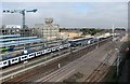
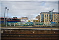
Cambridge Station: south end
The CB1 development is on the left, and work on the new platform and footbridge continues on the extreme right. The tall white castellated building is the former Spiller's Mill, partly destroyed by fire in March 2010 but due to be incorporated in the new development. The picture was taken from the top of the Cambridge Leisure car park.
Image: © John Sutton
Taken: 27 Sep 2011
0.00 miles
5
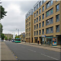
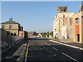
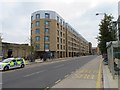
Bus stops on Station Place
The area around Cambridge Station has changed out of all recognition in the last ten years. Station Place is a new road, part of the CB1 development of former railway and commercial land. This is a view towards Station Square, taken on a cloudy October afternoon. Stops on this side of the road are used by buses going into the city and beyond, those on the other by buses heading to the southern suburbs and beyond.
Image: © John Sutton
Taken: 8 Oct 2021
0.01 miles
7
Cambridge Station and Spiller's Mill
A dullish photo taken three years ago has gained a little historical interest since Spiller's Mill - intended to become a cultural centre as part of the ambitious CB1 development west of the station - was largely destroyed by fire in the early hours of 27 March 2010. For an idea of the state of play at the end of March 2010, and how much of the building collapsed, see http://www.geograph.org.uk/photo/1777835, http://www.geograph.org.uk/photo/1777814 and others nearby. This picture, taken from Hills Road railway bridge, also shows, in the foreground, the edge of what was once the Cattle Market and is now the Cambridge Leisure complex, and, to the left of the train, disused sidings which have now given way to the unfinished track of the long-delayed and vastly over-budget guided-bus malarkey.
Image: © John Sutton
Taken: 2 Mar 2007
0.01 miles
8
Spiller's Mill and the station, from Hills Road bridge
Some work is being done on the mill, burnt out in a catastrophic fire on 27 March. Progress on the controversial, over-budget and long-delayed guided busway (behind the concrete wall left of centre) is less evident.
Image: © John Sutton
Taken: 4 Jun 2010
0.01 miles
9
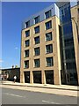
New houses by the station
Image: © Fernweh
Taken: 29 Oct 2016
0.01 miles
10
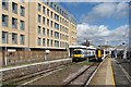
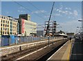
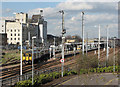
Cambridge Station: a changed view from Platform 2
The two stopping trains are in Platforms 3 and 2, with the new Rail Yard flats towering above them. Image] (August 2013) shows the same area before the flats were built.
Image: © John Sutton
Taken: 11 Apr 2015
0.01 miles