IMAGES TAKEN NEAR TO
De Vigier Avenue, SAFFRON WALDEN, CB10 2AY
Introduction
This page details the photographs taken nearby to De Vigier Avenue, CB10 2AY by members of the Geograph project.
The Geograph project started in 2005 with the aim of publishing, organising and preserving representative images for every square kilometre of Great Britain, Ireland and the Isle of Man.

There are currently over 7.5m images from over14,400 individuals and you can help contribute to the project by visiting https://www.geograph.org.uk
Image Map
Images are licensed for reuse under creativecommons.org/licenses/by-sa/2.0
Notes
- Clicking on the map will re-center to the selected point.
- The higher the marker number, the further away the image location is from the centre of the postcode.
Image Listing (11 Images Found)
Images are licensed for reuse under creativecommons.org/licenses/by-sa/2.0
Image
Details
Distance
1
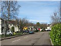
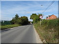
Making your house stand out in De Vigier Avenue
Someone's decided to brighten up this rather drab road on the edge of Saffron Walden.
David Hallam-Jones provided the following historical context to the name of the road. It is named after Swiss-born William de Vigier, who came to London in 1935 who invented the "Acrow prop". Apparently at first the old-fashioned builders preferred the established timber props, cut to fit for each job. However, the break for Vigier's adjustable props came when they were adopted by a few large builders, including McAlpines. By 1939, over 40,000 Acrow props were in use. Vigier’s company was named the Acrow Group, after his solicitor (Mr) A Crowe. Vigour adopted this name for his props as, like Kodak, it was an easily pronounceable neologism, with the additional advantage of appearing early in alphabetical lists. The nearby Ashdon Road Commercial
Centre was formerly home to an Acrow factory.
Image: © Colin Bell
Taken: 30 Mar 2008
0.08 miles
2
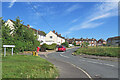
Saffron Walden: Whiteshot Way
Council-built houses off Ashdon Road near the eastern edge of the town.
Image: © John Sutton
Taken: 5 Sep 2023
0.13 miles
3
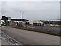
New housing development on Ashdon Road
On aerial photos this is shown as agricultural land. It will be a new housing estate. There are concerns about the traffic that will be generated on to what is a main road with the characteristics of a country lane.
Image: © Alan Hawkes
Taken: 18 Mar 2013
0.14 miles
6
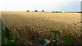
Cornfield
This photograph was taken from the same footpath in TL5438 that is featured as the link from Whiteshot Way to Buckenhoe Road.
Image: © Alan Hawkes
Taken: 27 Jul 2008
0.18 miles
7
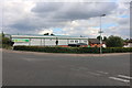
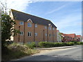
Homebase on Ashdon Road, Saffron Walden
Image: © David Howard
Taken: 23 Aug 2020
0.18 miles
9
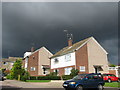
Storm clouds over Harvey Way
A dramatic sky behind sunlit buildings.
Image: © Alan Hawkes
Taken: 9 Sep 2010
0.23 miles
10
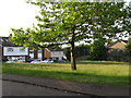
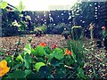
Open space with potential for play
This piece of land is on the junction of Dawson Way and Thorncroft. When Thorncroft was built this was left as a play area for children. The developer left it as rough land. Vegetation moved in and local children, both boys and girls, developed imaginative games. A local busybody kept pressuring the developer to do something with it. The developer returned, levelled the land and erected two sets of small goalposts - the cheapest option. The consequence was that boys played football, girls were banished and imaginative options lost. The local authority financial cuts have meant that the grass has been allowed to grow and a wild-flower meadow is beginning to emerge.
Image: © Alan Hawkes
Taken: 9 Jun 2014
0.24 miles