IMAGES TAKEN NEAR TO
Winskill Terrace, ALSTON, CA9 3PT
Introduction
This page details the photographs taken nearby to Winskill Terrace, CA9 3PT by members of the Geograph project.
The Geograph project started in 2005 with the aim of publishing, organising and preserving representative images for every square kilometre of Great Britain, Ireland and the Isle of Man.

There are currently over 7.5m images from over14,400 individuals and you can help contribute to the project by visiting https://www.geograph.org.uk
Image Map
Images are licensed for reuse under creativecommons.org/licenses/by-sa/2.0
Notes
- Clicking on the map will re-center to the selected point.
- The higher the marker number, the further away the image location is from the centre of the postcode.
Image Listing (77 Images Found)
Images are licensed for reuse under creativecommons.org/licenses/by-sa/2.0
Image
Details
Distance
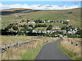
3
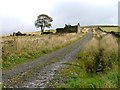
Ruin, Hardedge
The track is part of the Coast to Coast National Cycleway Route No. 7. View east from Whitehall towards Hardedge.
Image: © Mick Garratt
Taken: 1 Oct 2005
0.07 miles
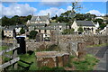
4
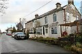
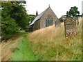
Chapel House Cottages, Whitehall
The building has been much altered but the name and form of the windows shows that it was once a Methodist Chapel, once the highest in England. Whitehall Primitive Methodist Chapel was built in 1823; rebuilt 1847; renovated 1893, and closed in 1938.
Image: © Andrew Curtis
Taken: 20 Oct 2020
0.07 miles
5
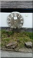
Stone Clock Face
Stone Clock Face built into house wall-clock originally in stone tower in the centre of Nenthead.
Part of the old Lead works
Image: © ken canham
Taken: 15 Jun 2020
0.09 miles
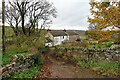
6
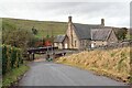
Terraced cottages, Wardway Foot
There is a photo of the stone clock face against the outer wall here Image
Known as 'Old Peter' it is the only surviving face from the clock tower which stood on the market house in Nenthead until the early 1900s. The market house was occupied by butchers, who used it for a weekly market.
Photo in Beamish Peoples Collection (NEG5369): http://collections.beamish.org.uk/search-detail?item=NEG5369 https://web.archive.org/web/http://collections.beamish.org.uk/search-detail?item=NEG5369
The building lives also lives on in the Nenthead Model Village Image
Image: © Andrew Curtis
Taken: 20 Oct 2020
0.10 miles
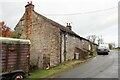
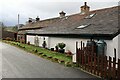
8
Nenthead Village Hall
A non-denominational school was built by London Lead Co. by 1818; this was replaced by the figured imposing new building in 1864 which is now used as Nenthead village hall. Inside there is a tablet to Robert Stagg, the agent for the London Lead Company, who started the first school in the Quaker's model mining village of Nenthead.
Image: © Andrew Curtis
Taken: 20 Oct 2020
0.11 miles