IMAGES TAKEN NEAR TO
ALSTON, CA9 3NG
Introduction
This page details the photographs taken nearby to CA9 3NG by members of the Geograph project.
The Geograph project started in 2005 with the aim of publishing, organising and preserving representative images for every square kilometre of Great Britain, Ireland and the Isle of Man.

There are currently over 7.5m images from over14,400 individuals and you can help contribute to the project by visiting https://www.geograph.org.uk
Image Map (Loading...)


Getting Data...Please wait
Leaflet Map data © OpenStreetMap
Images are licensed for reuse under creativecommons.org/licenses/by-sa/2.0
Notes
- Clicking on the map will re-center to the selected point.
- The higher the marker number, the further away the image location is from the centre of the postcode.
Image Listing (18 Images Found)
Images are licensed for reuse under creativecommons.org/licenses/by-sa/2.0
Image
Details
Distance
2
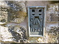
Ordnance Survey Flush Bracket 11743
This can be found on the wall of a building that used to house Pennine Pottery at Clarigillhead. The benchmark height is recorded as being 449.159 metres above sea level.
For more detail see : http://www.bench-marks.org.uk/bm22602
Image: © Peter Wood
Taken: 27 Mar 2017
0.02 miles
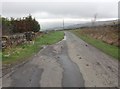
3
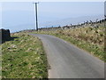
Track to road (A686) at Clargillhead
Looking south-westward.
Image: © Peter Wood
Taken: 27 Mar 2017
0.05 miles
4
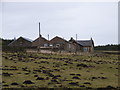
Clargillhead
The home of the Pennine Pottery, a tourist attraction.
Image: © Andrew Smith
Taken: 7 Mar 2006
0.05 miles
5
Lane from Cargillhead to A686
From outside Pennine Pottery
Image: © John Firth
Taken: 19 May 2013
0.09 miles
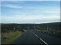
6

Isaac's Tea Trail near Clargillhead
This is where Isaac's Tea Trail meets the A686, look out for traffic especially motor bykes, when crossing road towards the Pennine Pottery or in the opposite direction down the Ayle Burn. The road can be very busy at weekends, in good weather. This is a popular route to the Lake District.
Image: © Roger Morris
Taken: 21 Jan 2009
0.12 miles
7
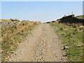
Track used by the Isaac's Tea Trail walk near Clargillhead
Looking north-eastward.
Image: © Peter Wood
Taken: 27 Mar 2017
0.12 miles
9
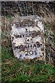
Old Milestone by the A686, west of Clargill Head
Carved stone post by the A686, in parish of ALSTON MOOR (EDEN District), West of Clargill Head, on grass verge, on bend above track to pottery, on East side of road. Haydon Bridge stone, erected by the Hexham to Alston turnpike trust in the 18th century.
Inscription reads:-
ALSTON
3
HAYDON B
14
HEXHAM
20½
Grade II Listed. List Entry Number: 1144995
https://historicengland.org.uk/listing/the-list/list-entry/1144995
Milestone Society National ID: CU_ALHX03.
Image: © CF Smith
Taken: 10 Nov 2009
0.15 miles
10
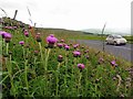
Melancholy Thistles (Cirsium heterophyllum) on road verge
A delight of the summer Pennine roadside verges.
Image: © Andrew Curtis
Taken: 19 Jul 2015
0.15 miles