IMAGES TAKEN NEAR TO
ALSTON, CA9 3BE
Introduction
This page details the photographs taken nearby to CA9 3BE by members of the Geograph project.
The Geograph project started in 2005 with the aim of publishing, organising and preserving representative images for every square kilometre of Great Britain, Ireland and the Isle of Man.

There are currently over 7.5m images from over14,400 individuals and you can help contribute to the project by visiting https://www.geograph.org.uk
Image Map
Images are licensed for reuse under creativecommons.org/licenses/by-sa/2.0
Notes
- Clicking on the map will re-center to the selected point.
- The higher the marker number, the further away the image location is from the centre of the postcode.
Image Listing (30 Images Found)
Images are licensed for reuse under creativecommons.org/licenses/by-sa/2.0
Image
Details
Distance
2
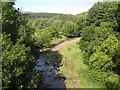
Gilderdale Burn (2)
Downstream of Gilderdale Bridge.
Image: © Mike Quinn
Taken: 27 Aug 2010
0.09 miles

5
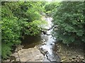
Looking south-west on the Gilderdale Burn
From the Gilderdale Bridge near Whitlow. Yet another stream full of flat bedrock.
Image: © James Denham
Taken: 22 Jun 2014
0.11 miles
6
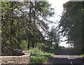
Gilderdale Bridge
Gilderdale Bridge carries the A689 over Gilderdale Burn; the stream and its passage beneath the bridge are shadowed in the image. The brightly sunlit, tapering pillar is a buttress of the south-west side of the bridge.
Ayle Common is in the distance.
Image: © Trevor Littlewood
Taken: 18 Sep 2020
0.11 miles
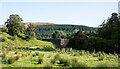
7
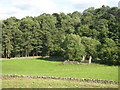
South Tyndale Railway below Howgill Rigg Farm
Parallel to the railway, a permissive footpath occupies part of the former railbed, which carries both the South Tyne Trail and the River Tyne Trail, sponsored by Daft as a Brush. The bridge ahead carries a track from the farm down to the River.
Image: © Oliver Dixon
Taken: 4 Nov 2020
0.11 miles
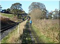
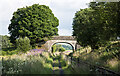
8
Bridge over the South Tynedale Railway
Seen from the railway bridge over Gilderdale Burn.
Image: © Helen Wilkinson
Taken: 29 Mar 2009
0.11 miles
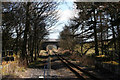
9
Bridge over South Tynedale Railway
The bridge carries a track from Howgill Rigg Farm. The path alongside the railway is the South Tyne Trail.
Image: © Clive Nicholson
Taken: 17 Dec 2021
0.12 miles
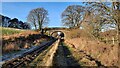
10
Bridge accommodating path and railway
The bridge is indeed probably an 'accommodation bridge', one which was required to be built by a railway company to connect land of a farm for example, which would otherwise have been made inaccessible by the railway line. The routes passing beneath the bridge now accommodated in a different sense, are the South Tyne Trail and the South Tynedale Railway.
Image: © Trevor Littlewood
Taken: 26 Jul 2021
0.12 miles