IMAGES TAKEN NEAR TO
Burnrigg, Heads Nook, BRAMPTON, CA8 9BH
Introduction
This page details the photographs taken nearby to CA8 9BH by members of the Geograph project.
The Geograph project started in 2005 with the aim of publishing, organising and preserving representative images for every square kilometre of Great Britain, Ireland and the Isle of Man.

There are currently over 7.5m images from over14,400 individuals and you can help contribute to the project by visiting https://www.geograph.org.uk
Image Map
Images are licensed for reuse under creativecommons.org/licenses/by-sa/2.0
Notes
- Clicking on the map will re-center to the selected point.
- The higher the marker number, the further away the image location is from the centre of the postcode.
Image Listing (11 Images Found)
Images are licensed for reuse under creativecommons.org/licenses/by-sa/2.0
Image
Details
Distance
1
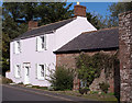
Former "Bay Horse", Burnrigg - September 2017 (1)
Believed to date from the 18th Century, the "Bay Horse" was a single room "ale house", situated on the ground floor of this building. It was closed by the State Management Scheme on 25 August 1916, the house becoming "Croft Farm" and is still marked as such on the current OS Map.
Private dwelling with no public access. See also: Image] and Image] .
Image: © The Carlisle Kid
Taken: 29 Sep 2017
0.04 miles
2
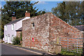
Former "Bay Horse", Burnrigg - September 2017 (2)
Long view of the former "Bay Horse" showing, at right, the altered "bothy" which once housed a coach and living accommodation for a coachman.
For information on this building, see: Image] .
Image: © The Carlisle Kid
Taken: 29 Sep 2017
0.04 miles
3
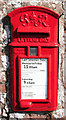
Former "Bay Horse", Burnrigg - September 2017 (3)
GVIR wall post box situated in the former bothy - see: Image] .
Image: © The Carlisle Kid
Taken: 29 Sep 2017
0.04 miles
4
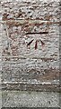
Benchmark near NE corner of Ivy Cottage
Ordnance Survey cut mark benchmark levelled at 48.105m above Newlyn Datum verified 1972
Image: © Roger Templeman
Taken: 31 Aug 2021
0.07 miles
5
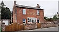
Ivy Cottage on west side of road
There is an Ordnance Survey benchmark Image on the front of the house about 1m from the far corner
Image: © Roger Templeman
Taken: 31 Aug 2021
0.08 miles
6
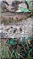
Benchmark on stone step of footpath stile on west side of road
Ordnance Survey pivot benchmark levelled at 46.480m above Newlyn Datum verified 1972
Image: © Roger Templeman
Taken: 31 Aug 2021
0.10 miles
7
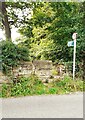
Stone step stile for footpath to Holme Eden Church from north end of Burnrigg
There is an Ordnance Survey benchmark Image on the right hand end of the top step of the stile
Image: © Roger Templeman
Taken: 31 Aug 2021
0.11 miles
8
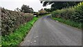
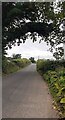
Approaching Burnrigg from the north
The house in the centre background is 'Robin Hill'
Image: © Luke Shaw
Taken: 31 Aug 2021
0.13 miles
9
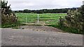
View through field gateway on NE side of rural road SE of Burnrigg
Roadside thistles showing seed heads
Image: © Roger Templeman
Taken: 31 Aug 2021
0.17 miles