IMAGES TAKEN NEAR TO
Cairn Wood, BRAMPTON, CA8 9AH
Introduction
This page details the photographs taken nearby to Cairn Wood, CA8 9AH by members of the Geograph project.
The Geograph project started in 2005 with the aim of publishing, organising and preserving representative images for every square kilometre of Great Britain, Ireland and the Isle of Man.

There are currently over 7.5m images from over14,400 individuals and you can help contribute to the project by visiting https://www.geograph.org.uk
Image Map
Images are licensed for reuse under creativecommons.org/licenses/by-sa/2.0
Notes
- Clicking on the map will re-center to the selected point.
- The higher the marker number, the further away the image location is from the centre of the postcode.
Image Listing (14 Images Found)
Images are licensed for reuse under creativecommons.org/licenses/by-sa/2.0
Image
Details
Distance
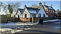
1
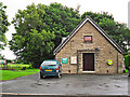
Heads Nook Village Hall
The plaque says 'Heads Nook Institute - 1924'. Nowadays generally referred to as the village hall, it can seat 120 people.
Image: © Rose and Trev Clough
Taken: 6 Jul 2016
0.09 miles
2
#1 Cairn Terrace on SW side of road in Heads Nook
Cladding has been applied around the base of the house
Image: © Roger Templeman
Taken: 20 Jan 2023
0.09 miles
3
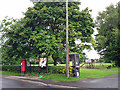
Village amenities, Heads Nook
Playing field, telephone and post boxes, two notice boards and a rubbish bin.
Image: © Rose and Trev Clough
Taken: 6 Jul 2016
0.10 miles
4
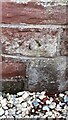
Benchmark on #2 The Old Corn Mill on SW side of village road
Ordnance Survey cut mark benchmark levelled at 78.673m above Newlyn Datum verified 1972
Image: © Roger Templeman
Taken: 26 Jan 2023
0.10 miles
5
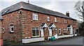
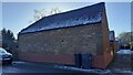
Nos 1,2,3 The Old Corn Mill and Farthing House
There is an Ordnance Survey benchmark Image on the front of the house with the white gate on the right hand side of its white door.
Image: © Roger Templeman
Taken: 26 Jan 2023
0.11 miles
6
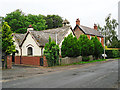
Converted church, Heads Nook
Looking at some old maps https://www.old-maps.co.uk/#/Map/349670/554900 the building was not there in 1901 but had appeared by 1925, marked as 'Church Room'. It is named on a 1968 map as 'St John's Church (C of E)'.
Image: © Rose and Trev Clough
Taken: 6 Jul 2016
0.12 miles
7
Kirklodge and Cairnville on SW side of village road
Image: © Luke Shaw
Taken: 20 Jan 2023
0.12 miles
8
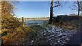
Field gateway on NE side of road in Heads Nook
Image: © Roger Templeman
Taken: 20 Jan 2023
0.12 miles
9
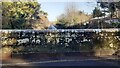
View over NE parapet of Bridge NEC2/153 of railway towards Newcastle
There is an Ordnance Survey benchmark Image on the ledge at the base of the parapet in the middle of the image
Image: © Luke Shaw
Taken: 20 Jan 2023
0.15 miles
10
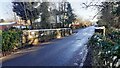
Bridge NEC2/153 in Heads Nook
There is an Ordnance Survey benchmark Image at the middle of the left hand parapet
Image: © Roger Templeman
Taken: 20 Jan 2023
0.15 miles