IMAGES TAKEN NEAR TO
Eals, Slaggyford, BRAMPTON, CA8 7PG
Introduction
This page details the photographs taken nearby to CA8 7PG by members of the Geograph project.
The Geograph project started in 2005 with the aim of publishing, organising and preserving representative images for every square kilometre of Great Britain, Ireland and the Isle of Man.

There are currently over 7.5m images from over14,400 individuals and you can help contribute to the project by visiting https://www.geograph.org.uk
Image Map
Images are licensed for reuse under creativecommons.org/licenses/by-sa/2.0
Notes
- Clicking on the map will re-center to the selected point.
- The higher the marker number, the further away the image location is from the centre of the postcode.
Image Listing (17 Images Found)
Images are licensed for reuse under creativecommons.org/licenses/by-sa/2.0
Image
Details
Distance
1
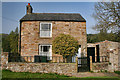
Holly Cottage
Holly Cottage in Eals.
Image: © Peter McDermott
Taken: 22 Apr 2011
0.03 miles
2
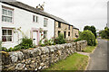
Row of cottages in Eals
Eals is a tiny settlement in the valley of the River South Tyne. The nearer of the homes is named 'Stonecrop'.
Image: © Trevor Littlewood
Taken: 26 Jul 2021
0.04 miles
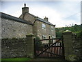
4
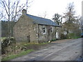
The Chapel, Eals.
The Wesleyan Chapel in Eals was built in 1871. It has since been converted into a house.
Image: © Les Hull
Taken: 10 Feb 2005
0.08 miles
5
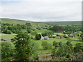
Eals from the South Tyne Trail
The hamlet of Eals in the South Tyne valley, viewed from the South Tyne Trail. The River South Tyne can just be seen at the bottom of shot.
This photograph was taken during the Coronavirus (COVID-19) pandemic of 2020/21.
Image: © James T M Towill
Taken: 13 Jun 2021
0.09 miles
7
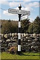
Direction Sign ? Signpost south of Eals
Located on the west side of a T junction south of Eals in Knarsdale with Kirkhaugh parish. 3 arms, 1 Worboys, and cone in cup finial.
Milestone Society National ID: NB_NY6855
Image: © A Lloyd
Taken: 15 Apr 2019
0.11 miles
8
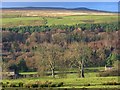
Pasture, Eals
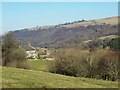
Looking across the South Tyne valley. Bands of colour are created by different types of woodland beyond the river, the contrast between improved and unimproved grassland and by the shadow cast over the top of the hillside.
Image: © Andrew Smith
Taken: 28 Nov 2008
0.12 miles