IMAGES TAKEN NEAR TO
Pennine Road, CA8 7AB
Introduction
This page details the photographs taken nearby to Pennine Road, CA8 7AB by members of the Geograph project.
The Geograph project started in 2005 with the aim of publishing, organising and preserving representative images for every square kilometre of Great Britain, Ireland and the Isle of Man.

There are currently over 7.5m images from over14,400 individuals and you can help contribute to the project by visiting https://www.geograph.org.uk
Image Map
Images are licensed for reuse under creativecommons.org/licenses/by-sa/2.0
Notes
- Clicking on the map will re-center to the selected point.
- The higher the marker number, the further away the image location is from the centre of the postcode.
Image Listing (17 Images Found)
Images are licensed for reuse under creativecommons.org/licenses/by-sa/2.0
Image
Details
Distance
1
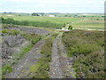
Railway path at Halton Lea Gate
This section of "Lord Carlisle's Railway" from Brampton to Lambley dates from 1824 and served the coal mines in the area; it was closed in 1953.
This stretch of the line has been upgraded to make a good path for walkers and cyclists. It offers cyclists the opportunity to ride for over 4 km from Halton Lea Gate to Tindale away from the A689 and although inadequately signed (there is no signage at this point where it meets a road) has been designated as "National Cycle Route 72". All quite misleading - the path is not connected at either end to signed cycle routes, nor does it make any connection with the main strand of Route 72 (Hadrian's Cycleway) some 7 km to the north.
Image: © Oliver Dixon
Taken: 24 Jun 2010
0.04 miles
2
The trackbed of Lord Carlisle's Railway east of Halton-Lea-Gate
The (former) railway, part of which was in use in the 18th C, was built by Lord Carlisle without an Act of Parliament as it was built on his own land. It carried coal from the various collieries along the line of what is now the A689 to Brampton. By the mid-19th C, the line connected the Haltwhistle to Alston line (at Lambley) with Brampton on the Newcastle to Carlisle line. It was one of the first non-Stephenson railways to convert and adopt the standard gauge of 4’8½" and in 1836 the ‘new railway’ opened officially under steam traction with The Rocket http://www.bbc.co.uk/history/british/victorians/launch_ani_rocket.shtml in use from the following year. For more info see http://www.cumbria-railways.co.uk/brampton_railway.html.
The line crossed the A689, with a level crossing, at a very acute angle - see the satellite image http://wtp2.appspot.com/wheresthepath.htm?lat=54.919823369785156&lon=-2.5388234853744507&gz=18&oz=8>=1.
The plume of smoke in the distance (left) is from controlled heather burning on Plenmeller Common.
Image: © Mike Quinn
Taken: 27 Feb 2013
0.07 miles
4
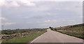
Approaching junction to Kellah from A689
Image: © John Firth
Taken: 18 May 2014
0.09 miles
5
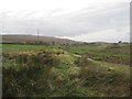
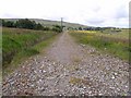
Bed of Old Railway Line
From Lambley to Tindale and eventually Carlisle.
Image: © Les Hull
Taken: 23 Nov 2011
0.10 miles
6
Dismantled Railway
This is part of the Brampton to Lambley railway (Lord Carlisle's Railway) and was built to service the various mines and works which existed in the 1800s. The line was started in the late 1700s at the western end and was finished in the mid 1800s at Lambley when it was connect to the Alston line. The line had a passenger service in the mid 1800s and again in the 1910s and was eventually closed by the NCB in 1953 and pulled up.
Image: © Alexander P Kapp
Taken: 4 May 2007
0.10 miles
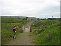
8
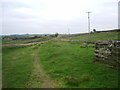
Track to the A689 near Halton Lea Gate
It is easy to miss the Pennine Way turning half right off this track.
Image: © Dave Kelly
Taken: 23 Jun 2022
0.11 miles
9
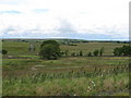
Sustrans Cycle Route72 near Halton-Lea-Gate
Image: © Les Hull
Taken: 23 Jul 2008
0.13 miles