IMAGES TAKEN NEAR TO
Naworth, BRAMPTON, CA8 2QT
Introduction
This page details the photographs taken nearby to CA8 2QT by members of the Geograph project.
The Geograph project started in 2005 with the aim of publishing, organising and preserving representative images for every square kilometre of Great Britain, Ireland and the Isle of Man.

There are currently over 7.5m images from over14,400 individuals and you can help contribute to the project by visiting https://www.geograph.org.uk
Image Map
Images are licensed for reuse under creativecommons.org/licenses/by-sa/2.0
Notes
- Clicking on the map will re-center to the selected point.
- The higher the marker number, the further away the image location is from the centre of the postcode.
Image Listing (19 Images Found)
Images are licensed for reuse under creativecommons.org/licenses/by-sa/2.0
Image
Details
Distance
1
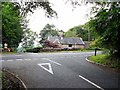
Lodge to the Naworth Castle estate
This lodge to the Naworth Castle estate now stands beside the busy A69 Carlisle to Newcastle road.
Image: © Oliver Dixon
Taken: 24 Jun 2010
0.01 miles
3
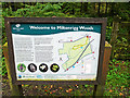
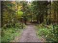
Information board, Miltonrigg Woods
This ancient woodland site, extending across 64ha, is owned by the Woodland Trust http://www.woodlandtrust.org.uk/visiting-woods/wood/4250/miltonrigg-woods/ .
The wood has good access for visitors - there is a car park and over 4.5km of footpaths.
Image: © Rose and Trev Clough
Taken: 19 Oct 2015
0.08 miles
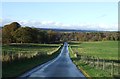
6
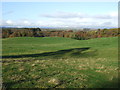
Miltonrigg Wood
A large area of mixed ancient woodland owned by the Woodland Trust.
Image: © Andrew Curtis
Taken: 29 Oct 2011
0.10 miles
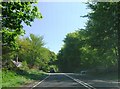
7
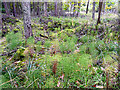
Ground flora, Miltonrigg Woods
This is beside a ride, where the canopy is fairly open. Larch predominates in this part of the wood, which is close to the A69. The plants in the foreground, looking like bright green brushes, are wood horsetail (Equisetum sylvaticum).
Image: © Rose and Trev Clough
Taken: 19 Oct 2015
0.13 miles
8
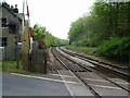
Naworth railway station (site), Cumbria
Opened in 1838 by the Newcastle & Carlisle Railway, later part of the North Eastern Railway, this was originally a private station. It became for use by the general public from 1877 and closed in 1962.
View north east towards Low Row and Newcastle.
Image: © Nigel Thompson
Taken: 10 May 2019
0.16 miles
9
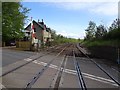
Railway
Looking towards Newcastle from the level crossing in Miltonrigg Wood
Image: © Alexander P Kapp
Taken: 4 May 2007
0.17 miles
10
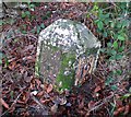
Old Milestone by the A69, south of Gowanholes Wood
Metal plates attached to stone post by the A69, in parish of BRAMPTON (CARLISLE District), South of Gowanholes Wood, 200 East of lane to Naworth Castle, on grass verge, on North side of road. Military Road plate, erected by the Carlisle & Temon (Military Road) turnpike trust in the 19th century.
Inscription reads:-
: TO NEW / CASTLE / 44 / MILES : : TO CAR / LISLE / 12 / MILES :
Carved benchmark.
Grade II Listed. List Entry Number: 1335526
https://historicengland.org.uk/listing/the-list/list-entry/1335526
Milestone Society National ID: CU_CLNC12.
Image: © CF Smith
Taken: 9 Dec 2009
0.18 miles