IMAGES TAKEN NEAR TO
Low Row, BRAMPTON, CA8 2LY
Introduction
This page details the photographs taken nearby to CA8 2LY by members of the Geograph project.
The Geograph project started in 2005 with the aim of publishing, organising and preserving representative images for every square kilometre of Great Britain, Ireland and the Isle of Man.

There are currently over 7.5m images from over14,400 individuals and you can help contribute to the project by visiting https://www.geograph.org.uk
Image Map
Images are licensed for reuse under creativecommons.org/licenses/by-sa/2.0
Notes
- Clicking on the map will re-center to the selected point.
- The higher the marker number, the further away the image location is from the centre of the postcode.
Image Listing (43 Images Found)
Images are licensed for reuse under creativecommons.org/licenses/by-sa/2.0
Image
Details
Distance
1
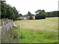
Chapelburn
Hamlet in the Irthing valley.
Image: © Oliver Dixon
Taken: 24 Jun 2010
0.00 miles
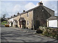
3
Chapelburn House B&B
Chapelburn House was built in 1820 as a coaching inn on the old Newcastle-Carlisle road. It has been some time since the house served paying guests but in 2007 we decided to buy the place and revive the tradition.
http://www.chapelburn.com/index.html
Image: © Les Hull
Taken: 7 Apr 2010
0.01 miles
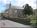
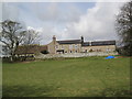
5
Chapelburn Farmhouse
Ordnance Survey documents indicate that a benchmark levelled at 108.753m above Newlyn Datum was verified in 1955 on the near corner, right hand face, of the house
Image: © Roger Templeman
Taken: 26 Apr 2023
0.05 miles
7
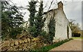
House near St Cuthbert's, Chapelburn
Being so close to the church this may have been a rectory although the outbuildings indicate that it could have been a farm. The outbuildings have been converted into living accommodation which indicates it might be a self-catering establishemnt. In truth I have no idea and I didn't see anything to indicate the present use of the building.
Image: © Les Hull
Taken: 7 Apr 2010
0.12 miles
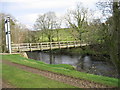
9
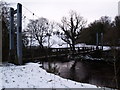
Pedestrian Suspension Bridge near Lanerton
Image: © Clive Nicholson
Taken: 24 Dec 2009
0.14 miles
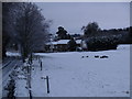
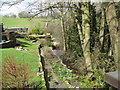
10
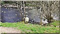
Stone on north bank of River Irthing west of Lanerton
The stone possibly marks the boundary of the parishes of Waterhead and Upper Denton: the boundary runs along the middle of the river.
Image: © Roger Templeman
Taken: 26 Apr 2023
0.14 miles