IMAGES TAKEN NEAR TO
Kirkhouse, BRAMPTON, CA8 1JS
Introduction
This page details the photographs taken nearby to CA8 1JS by members of the Geograph project.
The Geograph project started in 2005 with the aim of publishing, organising and preserving representative images for every square kilometre of Great Britain, Ireland and the Isle of Man.

There are currently over 7.5m images from over14,400 individuals and you can help contribute to the project by visiting https://www.geograph.org.uk
Image Map
Images are licensed for reuse under creativecommons.org/licenses/by-sa/2.0
Notes
- Clicking on the map will re-center to the selected point.
- The higher the marker number, the further away the image location is from the centre of the postcode.
Image Listing (7 Images Found)
Images are licensed for reuse under creativecommons.org/licenses/by-sa/2.0
Image
Details
Distance
1
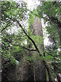
Kirkhouse Gasworks
Former colliery gasworks. Gas was generated from coke ovens.
Built in 1883 for the Earl of Carlisle, to provide lighting to the houses and workshops in the locality.
The building was converted to a colliery foundry c.1920.
It was Grade 2* Listed in 1984.
Image: © Matthew Hatton
Taken: 7 Oct 2016
0.05 miles
2
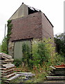
Old Building at Kirkhouse Gasworks
Originally marked as engine shed, it is later shown as ore hopper. The large metal door seems to be located where a rail line may have entered, and then presumably coal or coke was loaded into waiting waggons.
It is of sandstone and brick construction, and clearly of two different building periods.
Image: © Matthew Hatton
Taken: 7 Oct 2016
0.11 miles
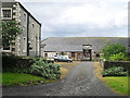
3
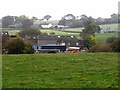
Farm buildings at Kirkhouse
These farm buildings have a venerable history, as they incorporate fragments of the old railway works, foundry, coke ovens and gasworks built by James Thompson, one of the major pioneers of steam locomotion. Immediately behind the buildings lies the course of "Lord Carlisle's Railway" which linked Brampton Junction station with the various mines and quarries in the vicinity of Hallbankgate.
Image: © Oliver Dixon
Taken: 15 Oct 2009
0.11 miles
4
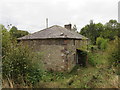
Bog Cottages
Now derelict, this row of cottages was built c.1883 to house workers for the nearby coke ovens and gas works. They are in rapid decline.
Image: © Matthew Hatton
Taken: 7 Oct 2016
0.12 miles
5
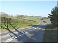
The A689 west of Milton
The road to the right leads to a sand and gravel pit. Just beyond, my car in parked in the lay-by.
Image: © John Baker
Taken: 27 Mar 2012
0.20 miles
6
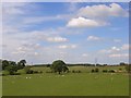
Pastures at Farlam
To the west of the road junction at Low Lonning. The pleasant green landscape is typical of this part of the Irthing valley.
Image: © John Hill
Taken: 26 May 2008
0.20 miles
7
Kirkhouse Farm
From the mid 18th to early 19th centuries, the Earl of Carlisle's coal and mineral operations were managed by successive colliery agents, who lived at this property in Kirkhouse. They were also responsible for running the farm, which provided food for the workers and horses. The last agent became a leaseholder, creating the firm of Thompson & Sons, which carried on until 1908 (information from 'Colliery settlements in east Cumberland', Harris 1974 https://archaeologydataservice.ac.uk/archiveDS/archiveDownload?t=arch-2055-1/dissemination/pdf/Article_Level_Pdf/tcwaas/002/1974/vol74/tcwaas_002_1974_vol74_0016.pdf ).
The front of the Grade II listed farmhouse can be seen here Image .
Image: © Rose and Trev Clough
Taken: 1 Sep 2015
0.24 miles