IMAGES TAKEN NEAR TO
Caldbeck, WIGTON, CA7 8HA
Introduction
This page details the photographs taken nearby to CA7 8HA by members of the Geograph project.
The Geograph project started in 2005 with the aim of publishing, organising and preserving representative images for every square kilometre of Great Britain, Ireland and the Isle of Man.

There are currently over 7.5m images from over14,400 individuals and you can help contribute to the project by visiting https://www.geograph.org.uk
Image Map
Images are licensed for reuse under creativecommons.org/licenses/by-sa/2.0
Notes
- Clicking on the map will re-center to the selected point.
- The higher the marker number, the further away the image location is from the centre of the postcode.
Image Listing (22 Images Found)
Images are licensed for reuse under creativecommons.org/licenses/by-sa/2.0
Image
Details
Distance
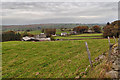
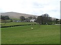
1
Fellside: seen from the moorland track to Little Fellside
Image: © Roger Smith
Taken: 25 Apr 2008
0.01 miles
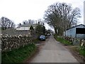
2
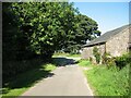
Cottages at Fell Side
The Cumbria Way low level alternative route from Skiddaw House to Nether Row follows the minor road from Green Head past these cottages at Fell Side (next photograph Image).
Image: © Adrian Taylor
Taken: 17 Aug 2016
0.01 miles
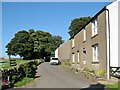
4
The Cumbria Way, Fell Side
Fell Side is a small farming community at the northernmost edge of the Lake District fells. It is on the route of The Cumbria Way low level alternative route from Skiddaw House to Nether Row (next photograph Image).
Image: © Adrian Taylor
Taken: 17 Aug 2016
0.04 miles
5
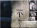
Benchmark, Fellside Manor (YHA Caldbeck)
Detail of the Ordnance Survey cut benchmark on the corner of an outbuilding in Fell Side beside The Cumbria Way. The benchmark marks a height of 284.9393m above sea level (Ordnance Datum Newlyn) last verified in 1970 (location photograph Image).
Image: © Adrian Taylor
Taken: 17 Aug 2016
0.04 miles
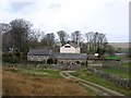
6
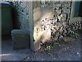
Corner of outbuilding, Fell Side
Detail of the sandstone quoins on the corner of an outbuilding beside The Cumbria Way at the former Fellside Manor, now YHA Caldbeck. On the left is a truncated sandstone wall that at one time carried decorative iron railings.
There is an Ordnance Survey cut benchmark on one of the quoins (photograph Image).
Image: © Adrian Taylor
Taken: 17 Aug 2016
0.04 miles
7
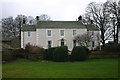
Fellside
Now an outdoor education centre for Cumbria CC
Image: © Bob Jenkins
Taken: 21 Dec 2005
0.04 miles
9
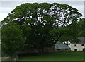
Mature Sycamore in Fell Side
This tree seems to dominate this farming hamlet.
Image: © Matthew Hatton
Taken: 23 May 2014
0.04 miles