IMAGES TAKEN NEAR TO
Cardurnock, Kirkbride, WIGTON, CA7 5AQ
Introduction
This page details the photographs taken nearby to CA7 5AQ by members of the Geograph project.
The Geograph project started in 2005 with the aim of publishing, organising and preserving representative images for every square kilometre of Great Britain, Ireland and the Isle of Man.

There are currently over 7.5m images from over14,400 individuals and you can help contribute to the project by visiting https://www.geograph.org.uk
Image Map
Images are licensed for reuse under creativecommons.org/licenses/by-sa/2.0
Notes
- Clicking on the map will re-center to the selected point.
- The higher the marker number, the further away the image location is from the centre of the postcode.
Image Listing (12 Images Found)
Images are licensed for reuse under creativecommons.org/licenses/by-sa/2.0
Image
Details
Distance
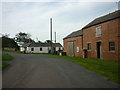
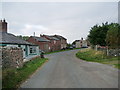
1
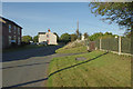
Cardurnock
The coast road between Anthorn and Bowness passes through this hamlet just to the north west of the Anthorn Radio Station site.
Image: © Stephen McKay
Taken: 2 Oct 2014
0.01 miles
3
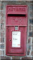
Elizabeth II postbox, Cardurnock
Postbox No. CA7 270.
See Image] for context.
Image: © JThomas
Taken: 28 May 2016
0.02 miles
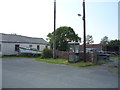
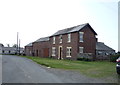
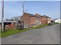
4
Farm buildings, Cardurnock
Postbox No. CA7 270.
See Image] for postbox.
Image: © JThomas
Taken: 28 May 2016
0.02 miles
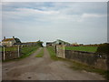
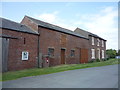
6
Cardurnock village
Hamlet at the tip of the Anthorn peninsula. The road is followed by Hadrian's Cycleway. It is hardly surprising to find that the telephone kiosk has been decommissioned.
Image: © Oliver Dixon
Taken: 9 Apr 2017
0.03 miles