IMAGES TAKEN NEAR TO
Brayton Park, WIGTON, CA7 3DF
Introduction
This page details the photographs taken nearby to Brayton Park, CA7 3DF by members of the Geograph project.
The Geograph project started in 2005 with the aim of publishing, organising and preserving representative images for every square kilometre of Great Britain, Ireland and the Isle of Man.

There are currently over 7.5m images from over14,400 individuals and you can help contribute to the project by visiting https://www.geograph.org.uk
Image Map
Images are licensed for reuse under creativecommons.org/licenses/by-sa/2.0
Notes
- Clicking on the map will re-center to the selected point.
- The higher the marker number, the further away the image location is from the centre of the postcode.
Image Listing (29 Images Found)
Images are licensed for reuse under creativecommons.org/licenses/by-sa/2.0
Image
Details
Distance
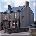
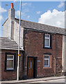
1
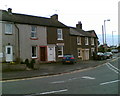
Cottages in Aspatria
On the junction of Queen Street, Lawson Street and Brayton Road
Image: © Adrian Taylor
Taken: 29 Oct 2006
0.03 miles
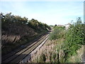
3
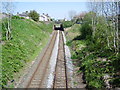
Railway
Looking towards Carlisle from Harriston Road Bridge
Image: © Alexander P Kapp
Taken: 3 May 2007
0.05 miles
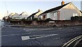
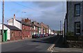
4
Houses, north side, Queen Street, Aspatria
Almost on top of the railway.
Image: © Christine Johnstone
Taken: 23 Oct 2014
0.05 miles
5
The Old Manse, Aspatria - May 2017
This was the Manse for Aspatria's "Primitive Methodist" Chapel, which was situated to the left of this building.
The Primitive Methodists built their Chapel and Manse here in 1886, but it closed in 1980 and was later demolished.
Information on the Primitive Methodist Chapel in Aspatria may be found: http://www.myprimitivemethodists.org.uk/page/aspatria_queen_street_adjacent_to_the_railway_bridge_pm_ii_chapel_cumberland?path=0p9p22p while details of the Primitive Methodist movement can be found on Wikipedia at: https://en.wikipedia.org/wiki/Primitive_Methodism
Image: © The Carlisle Kid
Taken: 14 May 2017
0.06 miles
7
Houses at junction of Brayton Road and Brayton Park
Image: © Roger Templeman
Taken: 10 Nov 2023
0.06 miles
8
Railway towards Carlisle
Looking north east from the bridge on Queen Street, Aspatria.
Image: © JThomas
Taken: 17 Sep 2016
0.07 miles
9
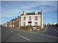
Former "Globe" public house - Aspatria - May 2017
Now a private dwelling named "The Globe Cottage", it was acquired by the State Management Scheme at an unrecorded date - probably October or November 1918 in common with other pubs in the town. Surprisingly for such small premises, it survived as a pub until sold to Greenall Whitley on 24 May 1973. Date of closure has not been found.
Image: © The Carlisle Kid
Taken: 14 May 2017
0.08 miles
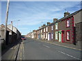
10
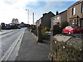
Lawson Street, Aspatria
The terraces in this area are notable for the range of cheerful colours they display.
Image: © Nigel Monckton
Taken: 2 Oct 2005
0.08 miles