IMAGES TAKEN NEAR TO
Old Chapel Close, WIGTON, CA7 2HJ
Introduction
This page details the photographs taken nearby to Old Chapel Close, CA7 2HJ by members of the Geograph project.
The Geograph project started in 2005 with the aim of publishing, organising and preserving representative images for every square kilometre of Great Britain, Ireland and the Isle of Man.

There are currently over 7.5m images from over14,400 individuals and you can help contribute to the project by visiting https://www.geograph.org.uk
Image Map
Images are licensed for reuse under creativecommons.org/licenses/by-sa/2.0
Notes
- Clicking on the map will re-center to the selected point.
- The higher the marker number, the further away the image location is from the centre of the postcode.
Image Listing (19 Images Found)
Images are licensed for reuse under creativecommons.org/licenses/by-sa/2.0
Image
Details
Distance
1
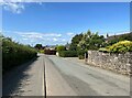
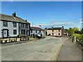
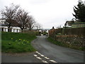
Bothel
This road through the village was the A595 from Whitehaven to Carlisle until Bothel was bypass was constructed.
Image: © Adrian Taylor
Taken: 29 Jun 2023
0.02 miles
2
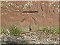
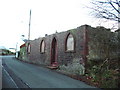
Benchmark, Bothel
Detail of the Ordnance Survey cut benchmark on the corner of a barn near the former Methodist Chapel in Bothel. The benchmark marks a height of 152.2811m above mean sea level (Ordnance Datum Newlyn) last verified in 1969 (location photograph Image).
Image: © Adrian Taylor
Taken: 2 Sep 2021
0.03 miles
3
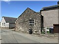
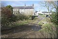
Old farm building, Bothel
This old limestone building was originally part of a farm.
The road in the foreground was formerly the A595 from Whitehaven to Carlisle before the village bypass was built.
There is an Ordnance Survey cut benchmark on the sandstone quoin, facing the road on the left hand corner of the building (detail photograph Image).
Image: © Adrian Taylor
Taken: 29 Jun 2023
0.03 miles
4
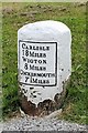
Old Milestone by the former A595 in Bothel
Metal plate attached to stone post by the UC road (was A595), in parish of BOTHEL AND THREAPLAND (ALLERDALE District), Bothel, former A595 opposite 'Langaith', on bank, on West side of road. Carlisle red stone and curved plate, erected by the Cockermouth & Carlisle turnpike trust in the 19th century.
Inscription reads:-
CARLISLE
18 MILES
WIGTON
8 MILES
COCKERMOUTH
7½ MILES
Grade II Listed. List Entry Number: 1144468
https://historicengland.org.uk/listing/the-list/list-entry/1144468
Milestone Society National ID: CU_CLCM18.
Image: © CF Smith
Taken: 11 Oct 2007
0.04 miles
5
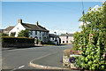
Houses in Bothel
The road was the A595 from Whitehaven to Carlisle before the completion of Bothel bypass.
Image: © Adrian Taylor
Taken: 29 Jun 2023
0.04 miles
6
Old chapel
Now being used as part of the garden to Corner Cottage
Image: © Alexander P Kapp
Taken: 21 Nov 2006
0.05 miles
7
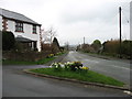
Main road through Bothel
Bothel is a small Cumbrian village now bypassed by the A591; once, presumably, the road in this image was the A591.
Image: © Trevor Littlewood
Taken: 10 Aug 2015
0.06 miles
10
Bothel Ford
This ford on the Bothel Beck is found at Bothel.
Image: © John Walton
Taken: 10 Mar 2015
0.14 miles