IMAGES TAKEN NEAR TO
Longtown, CARLISLE, CA6 5XP
Introduction
This page details the photographs taken nearby to CA6 5XP by members of the Geograph project.
The Geograph project started in 2005 with the aim of publishing, organising and preserving representative images for every square kilometre of Great Britain, Ireland and the Isle of Man.

There are currently over 7.5m images from over14,400 individuals and you can help contribute to the project by visiting https://www.geograph.org.uk
Image Map
Images are licensed for reuse under creativecommons.org/licenses/by-sa/2.0
Notes
- Clicking on the map will re-center to the selected point.
- The higher the marker number, the further away the image location is from the centre of the postcode.
Image Listing (17 Images Found)
Images are licensed for reuse under creativecommons.org/licenses/by-sa/2.0
Image
Details
Distance
2
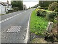
Old milestone
Looking southwards along the A7 at the Scotsdike border between Scotland and England. The little stream, Dimmisdaill Syke, disappears under the road surface. The metal cover has BT on it so the stream may reach the River Esk which is behind Rose Cottage on the east side of the road. Although the milestone is leaning it was like that in 2014 so is relatively safe.
Image: © Terry Moore
Taken: 26 Sep 2022
0.08 miles
3
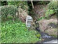
Old milestone
This milestone on the A7 which is the same style as others which have also lost their plates on the road towards Edinburgh is only just south of the border with Scotland. The little stream, Dimmisdaill Syke, which flows between two houses, Orchard View to the south in England and Eskdale Cottage to the north in Scotland is the line of the border. The narrow plate may have had Edinburgh 81½ with Carlisle 12½/Longtown 3½ on the lower plate.
Image: © Terry Moore
Taken: 26 Sep 2022
0.09 miles
4
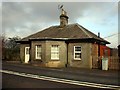
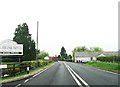
Tollhouse by the A7, Scotsdike, Kirkandrews parish
Tollhouse by the A7, in the parish of Canonbie (Dumfries & Galloway), Old Tollbooth, Scotsdike, just North of the border between England and Scotland. The most recent pictures show the house name as "Toll Booth, Tea Rooms". HES Category B listed. Reference: LB3529 http://portal.historicenvironment.scot/designation/LB3529 To be surveyed
Milestone Society National ID: DG.SCOTS
Image: © Milestone Society
Taken: Unknown
0.12 miles
5
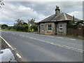
Old toll house
A newer photo of the tollhouse just north of the England/Scotland border at Scotsdike on the A7. It now has a satellite dish on the chimney and alterations to the southern end. There are two similar tollhouse on the A7 at the southern Image and northern Image ends of Langholm and one at Fiddleton Image
Image: © Terry Moore
Taken: 26 Sep 2022
0.12 miles
6
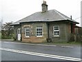
Former tollhouse
Surveyed by the Milestone Society. This Telford style tollhouse is on the A7 just over the border into Scotland at the Scotsdike and south of Canonbie. It may have had castellations above the front bay as the two tollhouses in Langholm and the fourth Telford tollhouse at Fiddleton.
Image: © Chris Minto
Taken: 30 Oct 2014
0.12 miles
8
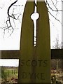
Scots Dyke sign
Sign marking the Scots Dyke, easily accessible from the A7 lay-by at the Border
Image: © Howard Mattinson
Taken: 4 Mar 2007
0.14 miles
9
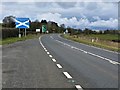
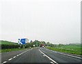
Entering Scotland along the A7
The A7 is the tourist route from Carlisle to Edinburgh.
The Scotland sign is slightly north of the border, so the lay-by from which this photograph was taken is actually in Scotland.
Image: © G Laird
Taken: 13 Mar 2018
0.15 miles