IMAGES TAKEN NEAR TO
Sandysike, Longtown, CARLISLE, CA6 5ST
Introduction
This page details the photographs taken nearby to CA6 5ST by members of the Geograph project.
The Geograph project started in 2005 with the aim of publishing, organising and preserving representative images for every square kilometre of Great Britain, Ireland and the Isle of Man.

There are currently over 7.5m images from over14,400 individuals and you can help contribute to the project by visiting https://www.geograph.org.uk
Image Map
Images are licensed for reuse under creativecommons.org/licenses/by-sa/2.0
Notes
- Clicking on the map will re-center to the selected point.
- The higher the marker number, the further away the image location is from the centre of the postcode.
Image Listing (22 Images Found)
Images are licensed for reuse under creativecommons.org/licenses/by-sa/2.0
Image
Details
Distance
1
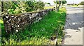
NW parapet of Parcelstown Bridge over Sandy Sike
There is an Ordnance Survey benchmark Image on top of the parapet at its near end
Image: © Roger Templeman
Taken: 1 Jun 2021
0.02 miles
2
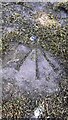
Benchmark on top of SW end of NW parapet of Parcelstown Bridge
Ordnance Survey rivet benchmark levelled at 13.054m above Newlyn Datum verified 1972
Image: © Roger Templeman
Taken: 1 Jun 2021
0.04 miles
3
Western parapet of Parcelstown Bridge
Ordnance Survey documents indicate that a benchmark was levelled at 39.255 feet above Liverpool Datum on this parapet during the 1844/5 Carlisle to Sark Bridge 1GL Survey. The surveyor's description was: 'No. 15. Mark on North pier of small bridge ; 2.01 ft. below mark on crown of battlement, and 0.92 ft. above surface'.
Image: © Luke Shaw
Taken: 4 Jun 2021
0.04 miles
6
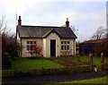
Sandysike Cottage on west side of old road through village
There is an 2007 photograph Image of the house before the detached garage was built.
Image: © Roger Templeman
Taken: 4 Jun 2021
0.11 miles
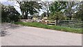
9
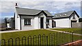
Cottage at Sandysike
On the old road to the east of the A7 at Sandysike, at the junction with Cliff Road. When this photograph was taken in 2007 it was thought that the cottage was an old tollhouse. Current (2021) thinking is that the Sandysike tollhouse was elsewhere and is now demolished.
Image: © Milestone Society
Taken: Unknown
0.13 miles
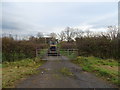
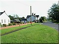
10
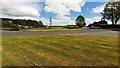
Junction of Cliff Road with old main road through Sandysike
Ordnance Survey records indicate that Sandysike toll house was located here with a benchmark levelled at 41.567 feet above Liverpool Datum during the 1844/5 Carlisle to Sark Bridge 1GL Survey. The surveyor's description was 'No. 16. Mark on South-west corner of Sandysikes Toll-house ; 1.47 ft. above surface'. See www.bench-marks.org.uk/bm79622
Image: © Roger Templeman
Taken: 4 Jun 2021
0.14 miles