IMAGES TAKEN NEAR TO
Crosby-on-Eden, CARLISLE, CA6 4QJ
Introduction
This page details the photographs taken nearby to CA6 4QJ by members of the Geograph project.
The Geograph project started in 2005 with the aim of publishing, organising and preserving representative images for every square kilometre of Great Britain, Ireland and the Isle of Man.

There are currently over 7.5m images from over14,400 individuals and you can help contribute to the project by visiting https://www.geograph.org.uk
Image Map
Images are licensed for reuse under creativecommons.org/licenses/by-sa/2.0
Notes
- Clicking on the map will re-center to the selected point.
- The higher the marker number, the further away the image location is from the centre of the postcode.
Image Listing (12 Images Found)
Images are licensed for reuse under creativecommons.org/licenses/by-sa/2.0
Image
Details
Distance
1

West House viewed over the north corner of its boundary wall
There is an Ordnance Survey benchmark Image on the corner wall pier on its left hand face, behind the roadside wooden fence
Image: © Roger Templeman
Taken: 14 Nov 2022
0.02 miles
2

Benchmark on corner pier of boundary wall of West Lodge on SE side of A689
Ordnance Survey cut mark benchmark levelled at 18.422m above Newlyn Datum verified 1972
Image: © Roger Templeman
Taken: 14 Nov 2022
0.03 miles
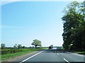
4
Cycle path alongside the A689
For 2 km, Hadrians Cycleway route 72 of the National Cycle Network ( http://www.cycle-routes.org/hadrianscycleway ) and the Cumbria Cycleway (although this is somewhat obsolescent) follow the busy A689. To keep cyclists of the carriageway, a cycle path has been constructed along the south side.
Image: © Oliver Dixon
Taken: 20 Jul 2006
0.12 miles
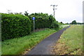
5

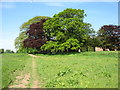
Sheep in field between Birkby Lane and A689
Image: © Luke Shaw
Taken: 14 Nov 2022
0.13 miles
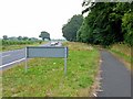
6
Footpath/cycle path into Low Crosby from A689 near East Lodge
This path is on the route of the old road with Crosby toll house where East Lodge is now. Ordnance Survey records show that in 1844 a benchmark levelled at 66.256 feet above Liverpool Datum was cut on the east jamb of the door of the toll house
Image: © Roger Templeman
Taken: 31 May 2019
0.22 miles
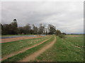
7
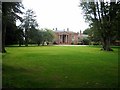
Eden Grove
This fine country house can be seen from Hadrian's Wall National Trail http://www.nationaltrail.co.uk/hadrianswall/
Image: © Oliver Dixon
Taken: 28 Aug 2008
0.23 miles
8
Hadrian's Wall Path passing Eden Grove
Image: © David Purchase
Taken: 31 May 2013
0.23 miles
9
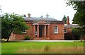
Eden Grove
Grade II listed building on Hadrian's Wall Path
Image: © Anthony Parkes
Taken: 5 Aug 2014
0.24 miles