IMAGES TAKEN NEAR TO
Armathwaite, CARLISLE, CA4 9TQ
Introduction
This page details the photographs taken nearby to CA4 9TQ by members of the Geograph project.
The Geograph project started in 2005 with the aim of publishing, organising and preserving representative images for every square kilometre of Great Britain, Ireland and the Isle of Man.

There are currently over 7.5m images from over14,400 individuals and you can help contribute to the project by visiting https://www.geograph.org.uk
Image Map
Images are licensed for reuse under creativecommons.org/licenses/by-sa/2.0
Notes
- Clicking on the map will re-center to the selected point.
- The higher the marker number, the further away the image location is from the centre of the postcode.
Image Listing (12 Images Found)
Images are licensed for reuse under creativecommons.org/licenses/by-sa/2.0
Image
Details
Distance
4
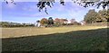
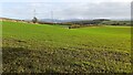
Farmland, Hesket
With trees lining the drive to Barrock End.
Image: © Andrew Smith
Taken: 5 Jan 2012
0.15 miles
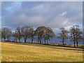
5
Fields on east side of road to Barrock End
Image: © Luke Shaw
Taken: 10 Nov 2021
0.17 miles
6
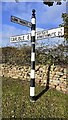
Cumberland County Council signpost at crossroads near Barrock End Cottages
The signpost has Milestone Society National ID: CU_NY4746
Image: © Roger Templeman
Taken: 10 Nov 2021
0.21 miles
7
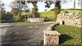
Crossroads at Barrock End Cottages
There is an old boundary stone Image against the boundary wall of the cottages, and a Cumberland County Council signpost Image at the far side of the crossroads
Image: © Roger Templeman
Taken: 10 Nov 2021
0.21 miles
8
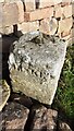
Benchmark on boundary stone at cross roads at Barrock End Cottages
Ordnance Survey pivot benchmark levelled at 150.963m above Newlyn Datum verified 1972
Image: © Roger Templeman
Taken: 10 Nov 2021
0.21 miles
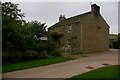
9
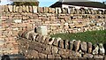
Boundary stone against wall of Barrock End Cottages
There is an Ordnance Survey benchmark Image on top of the stone which has Milestone Society National ID: CU_HESKET02pb
Image: © Roger Templeman
Taken: 10 Nov 2021
0.22 miles
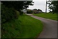
10
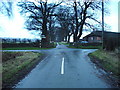
Road junction
Straight ahead to Barrock End, right to Aiketgate and left, back to the A6
Image: © Alexander P Kapp
Taken: 3 Jan 2007
0.22 miles