IMAGES TAKEN NEAR TO
Aiketgate, Armathwaite, CARLISLE, CA4 9TH
Introduction
This page details the photographs taken nearby to CA4 9TH by members of the Geograph project.
The Geograph project started in 2005 with the aim of publishing, organising and preserving representative images for every square kilometre of Great Britain, Ireland and the Isle of Man.

There are currently over 7.5m images from over14,400 individuals and you can help contribute to the project by visiting https://www.geograph.org.uk
Image Map (Loading...)


Getting Data...Please wait
Leaflet Map data © OpenStreetMap
Images are licensed for reuse under creativecommons.org/licenses/by-sa/2.0
Notes
- Clicking on the map will re-center to the selected point.
- The higher the marker number, the further away the image location is from the centre of the postcode.
Image Listing (17 Images Found)
Images are licensed for reuse under creativecommons.org/licenses/by-sa/2.0
Image
Details
Distance
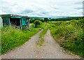
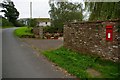
1
Lane in Aikengate
This is on the map as an 'Other route with public access', although presumably it should be classed as a Byway as it is the main street of the hamlet.
Image: © Humphrey Bolton
Taken: 4 Jul 2021
0.01 miles
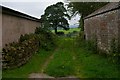
3
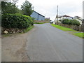
Minor road at Alketgate
Looking south-eastward.
Image: © Peter Wood
Taken: 11 Jul 2020
0.03 miles