IMAGES TAKEN NEAR TO
Ainstable, CARLISLE, CA4 9QW
Introduction
This page details the photographs taken nearby to CA4 9QW by members of the Geograph project.
The Geograph project started in 2005 with the aim of publishing, organising and preserving representative images for every square kilometre of Great Britain, Ireland and the Isle of Man.

There are currently over 7.5m images from over14,400 individuals and you can help contribute to the project by visiting https://www.geograph.org.uk
Image Map
Images are licensed for reuse under creativecommons.org/licenses/by-sa/2.0
Notes
- Clicking on the map will re-center to the selected point.
- The higher the marker number, the further away the image location is from the centre of the postcode.
Image Listing (14 Images Found)
Images are licensed for reuse under creativecommons.org/licenses/by-sa/2.0
Image
Details
Distance
1

Aimbank
The public footpath runs along the bottom of the garden of Aimbank and sets off up the middle of the field at the point the photograph was taken. Interestingly, the GPS I was using to geolocate photographs shows 1:50000 mapping which has the footpath passing through the farm, so it would appear to have been (sensibly) redirected fairly recently.
Image: © Andy Waddington
Taken: 28 Oct 2020
0.01 miles
2

Public footpath on the south side of Aimbank
The path has been diverted round the perimeter of the property.
Image: © Christine Johnstone
Taken: 22 Oct 2019
0.08 miles
3

Fallen leaves on the footpath near Aimbank
The public footpath has been diverted round the perimeter of the property.
Image: © Christine Johnstone
Taken: 22 Oct 2019
0.09 miles
4

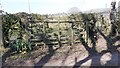
Public footpath stile with dog gate, at Aimbank
The path has been diverted round the southern edge of the property.
Image: © Christine Johnstone
Taken: 22 Oct 2019
0.09 miles
5

Public footpath to Rowfoot, west of Aimbank
Climbing a hillside, along the field edge.
Image: © Christine Johnstone
Taken: 22 Oct 2019
0.10 miles
6

Arable crop, between Aimbank and Faugh Head
About 110 metres above sea level.
Image: © Christine Johnstone
Taken: 22 Oct 2019
0.11 miles
7

Public footpath, north-west of Aimbank
There is a stile in the corner of the field.
Image: © Christine Johnstone
Taken: 22 Oct 2019
0.13 miles
8

Sheepfield, south of Rowfoot
Crossed by the public footpath from Bascodyke.
Image: © Christine Johnstone
Taken: 22 Oct 2019
0.17 miles
9
View of farmland through gate on north side of track west of Fearnlands
The track goes left to Aimbank
Image: © Luke Shaw
Taken: 17 Apr 2021
0.17 miles
10

Farmland between Bascodyke Foot and Aimbank
About 120 metres above sea level.
Image: © Christine Johnstone
Taken: 22 Oct 2019
0.19 miles