IMAGES TAKEN NEAR TO
Ruckcroft, Armathwaite, CARLISLE, CA4 9QS
Introduction
This page details the photographs taken nearby to CA4 9QS by members of the Geograph project.
The Geograph project started in 2005 with the aim of publishing, organising and preserving representative images for every square kilometre of Great Britain, Ireland and the Isle of Man.

There are currently over 7.5m images from over14,400 individuals and you can help contribute to the project by visiting https://www.geograph.org.uk
Image Map
Images are licensed for reuse under creativecommons.org/licenses/by-sa/2.0
Notes
- Clicking on the map will re-center to the selected point.
- The higher the marker number, the further away the image location is from the centre of the postcode.
Image Listing (10 Images Found)
Images are licensed for reuse under creativecommons.org/licenses/by-sa/2.0
Image
Details
Distance
1
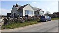
Bungalow south of track to Highfield Farm
There is an Ordnance Survey benchmark Image on the stone gatepost at the left hand end of the dry stone wall, beside a wooden gate
Image: © Luke Shaw
Taken: 17 Apr 2021
0.00 miles
2
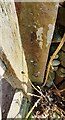
Benchmark on stone gatepost at access track to Highfield
Ordnance Survey cut mark benchmark levelled at 181.001m above Newlyn Datum verified in 1972
Image: © Luke Shaw
Taken: 17 Apr 2021
0.01 miles
3
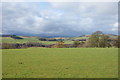
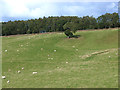
Green fields near Highfield Farm
This is on the opposite side of the road from the farm, looking west. In the far distance is the Blencathra range.
Image: © Bill Boaden
Taken: 7 Mar 2014
0.07 miles
4
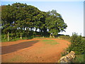
Red soil
Most of the buildings around here are built from red sandstone. Location just below Cross House farm
Image: © wfmillar
Taken: 14 Oct 2006
0.11 miles
7
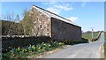
Barn at Cross House beside road to Ruckcroft
There is an Ordnance Survey benchmark Image on the near corner, road face, of the barn, hidden by daffodils in this image
Image: © Roger Templeman
Taken: 17 Apr 2021
0.21 miles
8
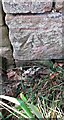
Benchmark on barn at Cross House Farm
Ordnance Survey cut mark benchmark levelled at 171.658m above Newlyn Datum verified in 1972
Image: © Roger Templeman
Taken: 17 Apr 2021
0.22 miles
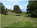
9
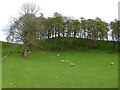
Sheep grazing and woodland near Cross House
Image: © JThomas
Taken: 29 Apr 2021
0.23 miles
10
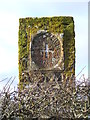
Sanctuary Pillar near Cross House, Ainstable
See other photograph of the pillar Image
Image: © harry hawkins
Taken: 28 Nov 2012
0.24 miles