IMAGES TAKEN NEAR TO
Ainstable, CARLISLE, CA4 9AS
Introduction
This page details the photographs taken nearby to CA4 9AS by members of the Geograph project.
The Geograph project started in 2005 with the aim of publishing, organising and preserving representative images for every square kilometre of Great Britain, Ireland and the Isle of Man.

There are currently over 7.5m images from over14,400 individuals and you can help contribute to the project by visiting https://www.geograph.org.uk
Image Map
Images are licensed for reuse under creativecommons.org/licenses/by-sa/2.0
Notes
- Clicking on the map will re-center to the selected point.
- The higher the marker number, the further away the image location is from the centre of the postcode.
Image Listing (11 Images Found)
Images are licensed for reuse under creativecommons.org/licenses/by-sa/2.0
Image
Details
Distance
1
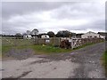
Faugh Head Caravan Site
A small private site restricted to Camping and Caravanning Club members.
Image: © Oliver Dixon
Taken: 4 Apr 2009
0.02 miles
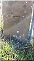
2
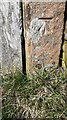
Benchmark on gatepost at gateway on north side of road opposite Faugh Head
Ordnance Survey cut mark benchmark levelled at 99.371m above Newlyn Datum verified 1972
Image: © Roger Templeman
Taken: 17 Apr 2021
0.09 miles
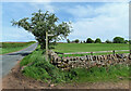
3
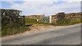
Field gateway on north side of rural road opposite Faugh Head
There is an Ordnance Survey benchmark Image on the stone gatepost at the right hand side of the gateway
Image: © Roger Templeman
Taken: 17 Apr 2021
0.09 miles
4
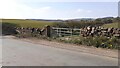
Field gateway on NW side of road NE of small stream near Faugh Head
There is an Ordnance Survey benchmark Image on the inside face of the left hand gatepost at the gateway
Image: © Luke Shaw
Taken: 17 Apr 2021
0.15 miles
5
Benchmark on gatepost on NW side of rural road SW of Rowfoot
Ordnance Survey cut mark benchmark levelled at 92.588m above Newlyn Datum verified in 1972
Image: © Luke Shaw
Taken: 17 Apr 2021
0.16 miles
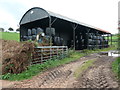
6
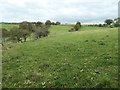
Farmland south-west of Faugh Head, Ainstable
About 100 metres above sea level.
Image: © Christine Johnstone
Taken: 22 Oct 2019
0.17 miles
7
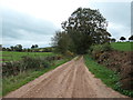
The track to Longdales
An 'other route with public access' heading south from the Armathwaite - Ainstable road.
Image: © Christine Johnstone
Taken: 22 Oct 2019
0.19 miles
8
Footpath near Ainstable
This path is part of a local network of routes.
Image: © Mary and Angus Hogg
Taken: 18 May 2022
0.20 miles
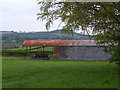
10
Barn filling up with wrapped bales
West of Faugh Head, Ainstable.
Image: © Christine Johnstone
Taken: 22 Oct 2019
0.21 miles