IMAGES TAKEN NEAR TO
Great Corby, CARLISLE, CA4 8NE
Introduction
This page details the photographs taken nearby to CA4 8NE by members of the Geograph project.
The Geograph project started in 2005 with the aim of publishing, organising and preserving representative images for every square kilometre of Great Britain, Ireland and the Isle of Man.

There are currently over 7.5m images from over14,400 individuals and you can help contribute to the project by visiting https://www.geograph.org.uk
Image Map
Images are licensed for reuse under creativecommons.org/licenses/by-sa/2.0
Notes
- Clicking on the map will re-center to the selected point.
- The higher the marker number, the further away the image location is from the centre of the postcode.
Image Listing (56 Images Found)
Images are licensed for reuse under creativecommons.org/licenses/by-sa/2.0
Image
Details
Distance
1
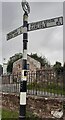
Cumberland County Council signpost at north side of Sandy Lane at Clints Road junction
The signpost has Milestone Society National ID: CU_NY4754B
The Cumberland CC provenance of the signpost is clear from the lettering on its post
Image: © Roger Templeman
Taken: 31 Aug 2021
0.02 miles
2
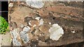
Close view of top of wall at junction of Clints Road with Sandy Lane
Ordnance Survey records indicate that a pivot benchmark levelled at 43.520m above Newlyn Datum was verified in 1972 on top of the wall here (see www.bench-marks.org.uk/bm142613 ). This image shows what might be a hole for a rivet and suggestion of arrow cuts. Adrian Taylor has a different opinion Image reporting the mark's demise which may well be correct!
Image: © Roger Templeman
Taken: 31 Aug 2021
0.02 miles
3
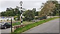
Wall with railings dividing Clints Road and Sandy Lane
There was/is? an Ordnance Survey benchmark Image on top of the wall at its near end
Image: © Roger Templeman
Taken: 31 Aug 2021
0.02 miles
4
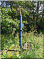
Village pump, Great Corby
Situated on the eastern side of the village, beside the Corby Beck (view of location here http://www.geograph.org.uk/photo/4716263 ).
The pump is topped with a heraldic cross. This comes from the coat of arms of the Howard family, who owned the Corby Castle Estate for nearly four centuries https://en.wikipedia.org/wiki/Corby_Castle .
Image: © Rose and Trev Clough
Taken: 28 Jun 2015
0.02 miles
5
Signpost, Great Corby
A traditional Cumberland County Council signpost at the junction of Sandy Lane and Clints Road in Great Corby. The signpost originally had a third arm directing to Burnrigg which was removed when Sandy Lane Level Crossing at Image was permanently closed to motor vehicles. There was an Ordnance Survey pivot benchmark on the end of the wall; it is no longer visible.
Image: © Adrian Taylor
Taken: 7 Mar 2021
0.02 miles
6
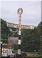
Direction Sign ? Signpost on Sandy Lane, Great Corby
Located in Great Corby on the northeast side of the Y junction of Sandy Lane and Clints Road, in Hayton parish. 3 arms, 1 missing, and annulus finial. See also http://www.geog.port.ac.uk/webmap/thelakes/photos/buz98.jpg and https://www.geograph.org.uk/photo/6776448.
Milestone Society National ID: CU_NY4754B
Image: © I Davison
Taken: Unknown
0.03 miles
7
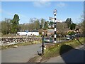
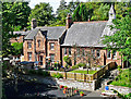
Great Corby - village scene
On the left is the parapet of a bridge across the Corby Beck. Behind that is the school. On the right is a grassy area with a bench and an old pump (see Image ) .
Image: © Rose and Trev Clough
Taken: 28 Jun 2015
0.03 miles
8
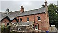
Great Corby primary school and nursery
There is an Ordnance Survey benchmark Image on the right hand corner of the building just through a gate in the wooden fence
Image: © Roger Templeman
Taken: 31 Aug 2021
0.03 miles
9
Great Corby School and Nursery
The school caters for children aged 3 to 11, 82 pupils were enrolled in 2014. The school became an academy in 2012.
The oldest part of the school (two storeys, on the left) was built in 1845. A single storey extension, with bellcote, was added in 1882 (information from Historic England http://www.imagesofengland.org.uk/details/default.aspx?id=77709 ).
Image: © Rose and Trev Clough
Taken: 28 Jun 2015
0.04 miles
10
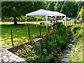
The lower village green, beside Corby Beck
The gazebo was there for the village garden trail event.
Image: © Rose and Trev Clough
Taken: 28 Jun 2015
0.04 miles