IMAGES TAKEN NEAR TO
Sowerby Row, CARLISLE, CA4 0QQ
Introduction
This page details the photographs taken nearby to CA4 0QQ by members of the Geograph project.
The Geograph project started in 2005 with the aim of publishing, organising and preserving representative images for every square kilometre of Great Britain, Ireland and the Isle of Man.

There are currently over 7.5m images from over14,400 individuals and you can help contribute to the project by visiting https://www.geograph.org.uk
Image Map
Images are licensed for reuse under creativecommons.org/licenses/by-sa/2.0
Notes
- Clicking on the map will re-center to the selected point.
- The higher the marker number, the further away the image location is from the centre of the postcode.
Image Listing (5 Images Found)
Images are licensed for reuse under creativecommons.org/licenses/by-sa/2.0
Image
Details
Distance
1
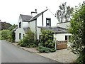
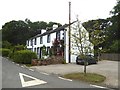
School House
Near Sowerby Road. It must be many years since this functioned as a school in such a remote area.
Image: © Oliver Dixon
Taken: 1 Aug 2018
0.01 miles
2
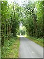
School Road
Tree-lined road running south-west from Sowerby Row.
Image: © Oliver Dixon
Taken: 1 Aug 2018
0.13 miles
3
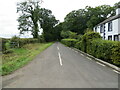
Minor road at Sowerby Row
Looking south-westward.
Image: © Peter Wood
Taken: 26 Sep 2020
0.17 miles
5
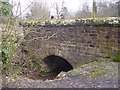
Bridge at Sowerby Row
The road crosses the tiny Oaker Gill.
Image: © Bob Jenkins
Taken: 24 Feb 2006
0.21 miles