IMAGES TAKEN NEAR TO
High Hesket, CARLISLE, CA4 0JG
Introduction
This page details the photographs taken nearby to CA4 0JG by members of the Geograph project.
The Geograph project started in 2005 with the aim of publishing, organising and preserving representative images for every square kilometre of Great Britain, Ireland and the Isle of Man.

There are currently over 7.5m images from over14,400 individuals and you can help contribute to the project by visiting https://www.geograph.org.uk
Image Map
Images are licensed for reuse under creativecommons.org/licenses/by-sa/2.0
Notes
- Clicking on the map will re-center to the selected point.
- The higher the marker number, the further away the image location is from the centre of the postcode.
Image Listing (44 Images Found)
Images are licensed for reuse under creativecommons.org/licenses/by-sa/2.0
Image
Details
Distance
1
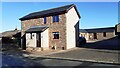
House #4 on main street through the village
There are a hydrant sign and GPO cable marker (see https://gpo-markers.derektp.co.uk/detail?post=106) against the house wall right of the house porch
Image: © Luke Shaw
Taken: 13 Nov 2021
0.02 miles
3
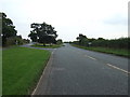
Turn off for High Hesket, A6
Heading south east.
Image: © JThomas
Taken: 10 Oct 2015
0.09 miles
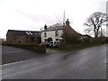
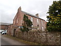
6
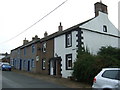
The Former Crown Inn, High Hesket
Now a private house, this was once the Crown Inn, one of several public houses once operating in this little village.
Image: © Trevor Harris
Taken: 6 Sep 2008
0.19 miles
7
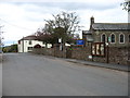
High Hesket village
St Mary's church and the Salutation Inn.
Image: © David Purchase
Taken: 28 Apr 2018
0.20 miles
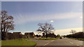
8
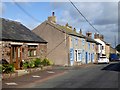
Village street at High Hesket
The main A6 used to run along this village street - fortunately, no longer!
Image: © Oliver Dixon
Taken: 1 Aug 2018
0.20 miles
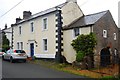
10
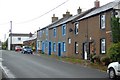
Cottages, High Hesket
This row of cottages lies between the former Crown Inn (just out of the photo on the right) up to the larger White House seen at the far end of the row. White House is opposite the Salutation Inn and the Church in the middle of the village. In the past several of these cottages were shops as well as dwellings One at the further end was, from the shop front still to be seen, in operation not so long ago. In the 1870's this row included two shoemakers, a dressmaker, a tailor and a blacksmith.
Image: © Trevor Harris
Taken: 6 Sep 2008
0.21 miles