IMAGES TAKEN NEAR TO
Etterby Road, CARLISLE, CA3 9PG
Introduction
This page details the photographs taken nearby to Etterby Road, CA3 9PG by members of the Geograph project.
The Geograph project started in 2005 with the aim of publishing, organising and preserving representative images for every square kilometre of Great Britain, Ireland and the Isle of Man.

There are currently over 7.5m images from over14,400 individuals and you can help contribute to the project by visiting https://www.geograph.org.uk
Image Map
Images are licensed for reuse under creativecommons.org/licenses/by-sa/2.0
Notes
- Clicking on the map will re-center to the selected point.
- The higher the marker number, the further away the image location is from the centre of the postcode.
Image Listing (73 Images Found)
Images are licensed for reuse under creativecommons.org/licenses/by-sa/2.0
Image
Details
Distance
1
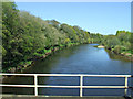
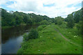
The River Eden
Viewed from a Glasgow bound train.
Image: © Thomas Nugent
Taken: 18 Apr 2014
0.05 miles
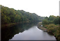
3
River Eden, Etterby
Looking upstream.
Image: © Robin Webster
Taken: 14 Sep 2019
0.06 miles
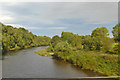
4
The River Eden
Looking upstream from the Hadrian's Wall Path on a bright but chilly late-January morning.
Image: © Mary and Angus Hogg
Taken: 31 Jan 2015
0.07 miles
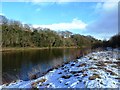
5
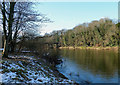
River Eden
A winter view looking downstream towards the railway bridge across the Eden.
Image: © Mary and Angus Hogg
Taken: 31 Jan 2015
0.07 miles
6
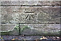
Benchmark on Etterby Road railway bridge
Ordnance Survey cut mark benchmark described on the Bench Mark Database at http://www.bench-marks.org.uk/bm30945
Image: © Roger Templeman
Taken: 24 Jul 2015
0.08 miles
7
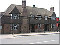
Redfern Inn, Etterby
The Redfern Inn is one of several Public Houses in Carlisle built in this style by the British architect Harry Redfern (1861-1950).
Harry Redfern was commemorated towards the end of his work for the State Management Scheme by the naming of the Redfern Inn (1938), one of the distinctive New Model Inn designs, in Etterby, a district of Carlisle. The Redfern was designed by his assistant architect, Joseph Seddon, FRIBA (with Redfern's collaboration). It was a tribute to a man who had dedicated his talents to the quest for an improved public house style.
The State Management Scheme (known locally as 'The Scheme') saw the UK government take over and run the brewing, distribution and sale of liquor in three regions of the UK from 1916 until 1973. [1] The main centre was the Carlisle and District scheme, which was near to the armament factories that were founded in 1916 supplying explosive and shells to the British Army during the First World War.
There were initially three schemes, Carlisle & Gretna, Cromarty Firth and Enfield. In 1921 Carlisle and Gretna were split into two separate areas, Carlisle was the large part and supplied some beer to Gretna. Then in 1922 Enfield was ended and the public houses sold back to private enterprise. The Cromarty Firth scheme did not do any brewing.
[1]Significant to the scheme was the extensive redevelopment; refurbishment of existing pubs, much demolition and replacement of substandard premises, most of these were designed by the Scheme's chief architect Harry Redfern and in his New Model Inn style which influenced the design of public houses in the rest of the UK.
Image: © Andy Connor
Taken: 8 Jun 2008
0.08 miles
8
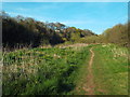
Riverside path, Carlisle
This path follows the south bank of the River Eden.
Image: © Malc McDonald
Taken: 23 Apr 2015
0.08 miles
9
The River Eden
Hadrian's Wall Path can also be seen. Viewed from a south bound train on the West Coast Main Line.
Image: © Thomas Nugent
Taken: 6 Jul 2020
0.08 miles
10
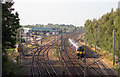
Evening at Etterby - September 2016 (3)
Electric unit 350403 approaches the Eden Valley Viaduct at Etterby with the 15.09 passenger service from Glasgow to Manchester Airport. The DRS facilities at Kingmoor can be seen on the left.
Image: © The Carlisle Kid
Taken: 15 Sep 2016
0.09 miles