IMAGES TAKEN NEAR TO
Walden Grove, CARLISLE, CA3 9JT
Introduction
This page details the photographs taken nearby to Walden Grove, CA3 9JT by members of the Geograph project.
The Geograph project started in 2005 with the aim of publishing, organising and preserving representative images for every square kilometre of Great Britain, Ireland and the Isle of Man.

There are currently over 7.5m images from over14,400 individuals and you can help contribute to the project by visiting https://www.geograph.org.uk
Image Map
Images are licensed for reuse under creativecommons.org/licenses/by-sa/2.0
Notes
- Clicking on the map will re-center to the selected point.
- The higher the marker number, the further away the image location is from the centre of the postcode.
Image Listing (44 Images Found)
Images are licensed for reuse under creativecommons.org/licenses/by-sa/2.0
Image
Details
Distance
1
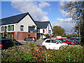
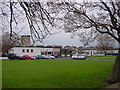
North Carlisle Medical Centre
Opened in April 2014, the Centre houses a medical practice, community health services and a pharmacy.
The land was formerly occupied by Belah School, which closed in 2008 and was demolished about eighteen months later - see photo taken in 2006 Image .
Image: © Rose and Trev Clough
Taken: 14 Oct 2015
0.08 miles
2
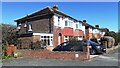
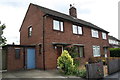
Semi-detached houses on NW side of Waverley Road
Ordnance Survey records indicate that a benchmark levelled at 18.459m above Newlyn Datum was verified in 1974 on the front corner, left hand face, of the nearest house (No. 24). However, an extension has been added on this face with loss of the benchmark
Image: © Luke Shaw
Taken: 15 Apr 2021
0.09 miles
5
Benchmark on #86 Eden Street
Ordnance Survey cut mark benchmark described on the Bench Mark Database at http://www.bench-marks.org.uk/bm69302
Image: © Roger Templeman
Taken: 24 Jul 2015
0.11 miles
6
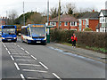
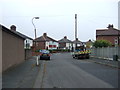
Carlisle, Bus Stop on Scotland Road (A7)
Stagecoach Cumbria & North Lancashire 25226 (PX08 FMV), an Optare V1110 Versa midibus, at the bus stop on Scotland Road.
Image: © David Dixon
Taken: 2 Mar 2020
0.11 miles
7
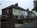
Nos. 86 and 84 Eden Street
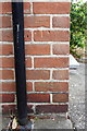
There is an OS benchmark Image on the corner, left hand face, of the nearer house, right of the black downpipe
Image: © Roger Templeman
Taken: 24 Jul 2015
0.11 miles
8
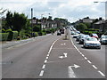
Scotland Road, Carlisle (A7)
Looking south in the direction of Carlisle City Centre.
Image: © G Laird
Taken: 6 Aug 2009
0.12 miles
9
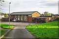
Belah Primary School
Flat roofed post-war construction.
Image: © Bob Jenkins
Taken: 13 Jan 2006
0.12 miles
10
St Augustine's Parish Centre
The building predates the current RC parish church in the same grounds, which was dedicated in 1979 (photo Image ).
It was occupied for many years by St Augustine’s Social Club, which closed in 2008.
Not long after this photo was taken (August 2012), the Parish Centre was demolished. The site has been redeveloped with retirement apartments, named Waverley Court.
Image: © Rose and Trev Clough
Taken: 26 Aug 2012
0.13 miles