IMAGES TAKEN NEAR TO
Lansdowne Crescent, CARLISLE, CA3 9ER
Introduction
This page details the photographs taken nearby to Lansdowne Crescent, CA3 9ER by members of the Geograph project.
The Geograph project started in 2005 with the aim of publishing, organising and preserving representative images for every square kilometre of Great Britain, Ireland and the Isle of Man.

There are currently over 7.5m images from over14,400 individuals and you can help contribute to the project by visiting https://www.geograph.org.uk
Image Map
Images are licensed for reuse under creativecommons.org/licenses/by-sa/2.0
Notes
- Clicking on the map will re-center to the selected point.
- The higher the marker number, the further away the image location is from the centre of the postcode.
Image Listing (16 Images Found)
Images are licensed for reuse under creativecommons.org/licenses/by-sa/2.0
Image
Details
Distance
1
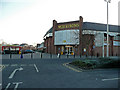
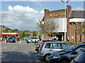
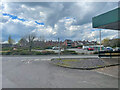
Morrisons supermarket, Kingstown Road, Carlisle
To the east of the A7 heading north out of town.
Image: © Jonathan Billinger
Taken: 13 Feb 2008
0.15 miles
4
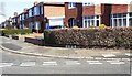
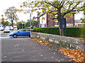
Houses at Lansdowne Crescent / Beechwood Avenue junction
There is an Ordnance Survey benchmark Image on the concrete surround of the Post Office Telephones inspection chamber cover at the corner of the pavement
Image: © Roger Templeman
Taken: 15 Apr 2021
0.18 miles
5

Benchmark on surround of Post Office telephones inspection cover
The Ordnance Survey pivot benchmark on the concrete surround in the pavement at the junction of Lansdowne Crescent and Beechwood Avenue was levelled at 19.911m above Newlyn Datum and verified in 1972
Image: © Roger Templeman
Taken: 15 Apr 2021
0.19 miles
6
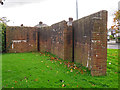
Back of mystery wall, Scotland Road
Front view here Image .
Quite a complex shape and looks well built. We do not know its purpose.
Possibly protecting a culverted beck, Gosling Sike, which flows underground in this vicinity - there is an old bridge parapet on the opposite side of the road Image
Image: © Rose and Trev Clough
Taken: 18 Oct 2017
0.19 miles
7
Mystery wall, Scotland Road
It's standing on a patch of grass, not attached to anything. Somebody wrote a letter to the Cumberland News (18.11.2016) asking if anyone knows why it's there, but no replies were printed.
View from the other side here Image .
Image: © Rose and Trev Clough
Taken: 18 Oct 2017
0.20 miles
8
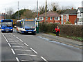
Carlisle, Bus Stop on Scotland Road (A7)
Stagecoach Cumbria & North Lancashire 25226 (PX08 FMV), an Optare V1110 Versa midibus, at the bus stop on Scotland Road.
Image: © David Dixon
Taken: 2 Mar 2020
0.20 miles
9

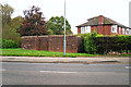
Gosling Bridge name stone on SW side of Kingstown Road
The stone indicates that the bridge was widened in 1898 and has Milestone Society National ID: CU_CL07br
Image: © Roger Templeman
Taken: 17 Jan 2022
0.20 miles
10
Gosling Bridge
On Scotland Road, near the junction with Waverley Road.
There's no sign of any water, but the stone wall is an old bridge parapet. Looking closely, its name can be seen in an inscription Image .
The bridge crosses Gosling Sike, a small stream which starts at Houghton and joins the River Eden near Etterby Terrace https://www.geograph.org.uk/photo/5174219 . It is culverted from Scotland Road to the outfall, flowing beneath the grounds of St Augustine's Church on the right of the parapet.
Image: © Rose and Trev Clough
Taken: 18 Oct 2017
0.20 miles