IMAGES TAKEN NEAR TO
Brampton Road, CARLISLE, CA3 9AW
Introduction
This page details the photographs taken nearby to Brampton Road, CA3 9AW by members of the Geograph project.
The Geograph project started in 2005 with the aim of publishing, organising and preserving representative images for every square kilometre of Great Britain, Ireland and the Isle of Man.

There are currently over 7.5m images from over14,400 individuals and you can help contribute to the project by visiting https://www.geograph.org.uk
Image Map
Images are licensed for reuse under creativecommons.org/licenses/by-sa/2.0
Notes
- Clicking on the map will re-center to the selected point.
- The higher the marker number, the further away the image location is from the centre of the postcode.
Image Listing (38 Images Found)
Images are licensed for reuse under creativecommons.org/licenses/by-sa/2.0
Image
Details
Distance
1

Brampton Road (B6264), Carlisle
Showing position of milestone - Image]
Image: © JThomas
Taken: 20 Nov 2019
0.02 miles
2
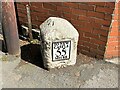
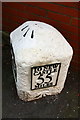
Benchmark, Milestone, Brampton Road
Detail of the Ordnance Survey pivot benchmark on the top of the 'Carlisle 1 mile' / 'Newcastle 55 miles' milestone on the southeast side of the B6264 Brampton Road (location photograph Image). The most recent of the two benchmarks on this milestone, this benchmark marks a height of 25.1404m above mean sea level (Ordnance Datum Newlyn) last verified in 1972.
Image: © Adrian Taylor
Taken: 29 Jun 2023
0.02 miles
3
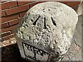
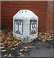
Milestone, Brampton Road
On the south side of the B6264 Brampton Road between house numbers 18 and 20 (location photograph Image), this 19th Century milestone is unusual in carrying two Ordnance Survey benchmarks.
There is a cut benchmark on the west side of the stone near the base (detail photograph Image), and a pivot benchmark on the top of the stone.
The milestone has lost its original metal plates and new replica ones have been fitted closely matching the originals, which read 'To Carlisle 1 mile' and 'To Newcastle 55 miles' (details of the milestone before restoration Image).
Image: © Adrian Taylor
Taken: 29 Jun 2023
0.02 miles
4
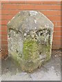
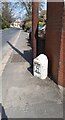
Milestone, Brampton Road
On the south side of Brampton Road between numbers 18 and 20, a 19th Century milestone (close look Image) is dwarfed by a modern telephone distribution pole.
Image: © Adrian Taylor
Taken: 29 Jun 2023
0.02 miles
5
Old Milestone by the B6264, north of Carlisle
Stone post (plates lost) by the B6264 (was A689), in parish of CARLISLE (CARLISLE District), Brampton Road opposite sports fields, by Eden Brae House (No. 20) against wall, on South side of road. Military Road plate, erected by the Carlisle & Temon (Military Road) turnpike trust in the 19th century.
Inscription once read:-
(TO / CAR / LISLE / I / MILE) : : (TO NEW / CASTLE / 55 / MILES) :
Carved benchmark below right panel.
Milestone Society National ID: CU_CLNC01.
Image: © CF Smith
Taken: 17 Nov 2009
0.02 miles
6
Milestone on SE side of Brampton Road with two benchmarks
The stone has obviously been restored since the photo at Image There is an Ordnance Survey pivot benchmark on its top, levelled at 25.14m above Newlyn Datum, and a cut mark benchmark at the base of the stone
Image: © Roger Templeman
Taken: 16 Sep 2019
0.02 miles
7
Milestone on Brampton Road
Inscription reads:- TO CAR / LISLE I MILE TO NEW / CASTLE 55 MILES
Also has two benchmarks.
Milestone Society National ID: CU_CLNC01.
Image: © JThomas
Taken: 20 Nov 2019
0.03 miles
8
Looking NE along Brampton Road (B6264)
The milestone Image carries two Ordnance Survey benchmarks, the cut mark can b seen below the mileage plate: see www.bench-marks.org.uk/bm108264
Image: © Roger Templeman
Taken: 16 Apr 2021
0.03 miles
9
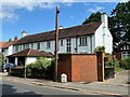
University campus, Brampton Road, Carlisle
The Brampton Road campus of the University of Cumbria seen from the road from which the site takes its name.
Image: © Graham Robson
Taken: 6 Oct 2018
0.05 miles
10
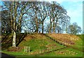
Climbing Hadrian's Wall
These steps climb up to the high ground which the Romans used for Hadrian's Wall in AD122. A winter view from Rickerby Park.
Image: © Mary and Angus Hogg
Taken: 24 Jan 2015
0.08 miles