IMAGES TAKEN NEAR TO
West Walls, CARLISLE, CA3 8UF
Introduction
This page details the photographs taken nearby to West Walls, CA3 8UF by members of the Geograph project.
The Geograph project started in 2005 with the aim of publishing, organising and preserving representative images for every square kilometre of Great Britain, Ireland and the Isle of Man.

There are currently over 7.5m images from over14,400 individuals and you can help contribute to the project by visiting https://www.geograph.org.uk
Image Map
Images are licensed for reuse under creativecommons.org/licenses/by-sa/2.0
Notes
- Clicking on the map will re-center to the selected point.
- The higher the marker number, the further away the image location is from the centre of the postcode.
Image Listing (1601 Images Found)
Images are licensed for reuse under creativecommons.org/licenses/by-sa/2.0
Image
Details
Distance
1
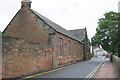
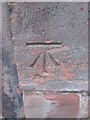
Hall on West Walls
There is an OS benchmark Image on a corner stone of the building at its junction with the abutting wall
Image: © Roger Templeman
Taken: 16 Jun 2012
0.01 miles
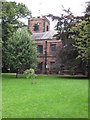
2
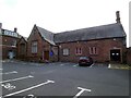
St George's United Reformed Church
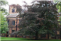
The United Reformed Church, West Walls, Carlisle was formerly the 'Diocesan Church Centre' and before that a school. It is Grade II listed https://historicengland.org.uk/listing/the-list/list-entry/1218930 Dating from 1832 the Grammar School was of royal foundation and formed part of the Cathedral, hence within the Cathedral grounds, It is on the site of the former malt kiln of the Priory of St Mary and became the Choir School of the Cathedral when a new Grammar School was built in 1883. It was threatened with demolition in 1977.
Image: © Gerald England
Taken: 11 Sep 2021
0.01 miles
3
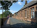
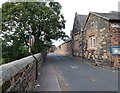
View along West Walls
The building on the right is the former Grammar School of Carlisle Cathedral, dating from 1832, Listed Grade II. Now the Diocesan Church Centre, following reprieve from demolition in 1977.
There is a bench mark http://www.geograph.org.uk/photo/1966953 at the far end of the main building.
Image: © Alan Murray-Rust
Taken: 8 Jul 2018
0.01 miles
4
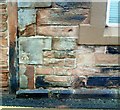
Benchmark on Hall in West Walls
Details of the Ordnance Survey cut mark benchmark may be found on the Bench Mark Database at http://www.bench-marks.org.uk/bm34888.
Image: © Roger Templeman
Taken: 17 Jul 2010
0.01 miles
5
Ordnance Survey Cut Mark
This OS cut mark can be found on the Hall on the NE side of Wall Street. It marks a point 24.594m above mean sea level.
Image: © Adrian Dust
Taken: 12 Apr 2016
0.01 miles
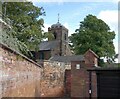
6
St Cuthbert's Church, Carlisle
The present Church is probably the fourth on this site and dates from 1778. St Cuthbert is believed to have visited Carlisle in 685.
Image: © Philip Halling
Taken: 26 Aug 2008
0.01 miles
7
St Cuthbert with St Mary
The Grade II* listed https://historicengland.org.uk/listing/the-list/list-entry/1218565 church of St Cuthbert with St Mary is dated 1778 on the weather vane Image, and was built by Messrs Hayton, Lowthian and Lowrey on a medieval site.
Image: © Gerald England
Taken: 11 Sep 2021
0.02 miles
8
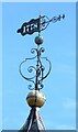
St Cuthbert with St Mary: Weathervane
The Grade II* listed https://historicengland.org.uk/listing/the-list/list-entry/1218565 church of St Cuthbert with St Mary is dated 1778 on the weather vane, and was built by Messrs Hayton, Lowthian and Lowrey on a medieval site.
The weather vane atop St Cuthbert with St Mary Image
Image: © Gerald England
Taken: 11 Sep 2021
0.02 miles
10
West Walls
The building on the right is the Grade II listed https://historicengland.org.uk/listing/the-list/list-entry/1218930 former Grammar School, now St George's United Reformed Church Image
Image: © Gerald England
Taken: 11 Sep 2021
0.02 miles