IMAGES TAKEN NEAR TO
Lowther Street, CARLISLE, CA3 8EE
Introduction
This page details the photographs taken nearby to Lowther Street, CA3 8EE by members of the Geograph project.
The Geograph project started in 2005 with the aim of publishing, organising and preserving representative images for every square kilometre of Great Britain, Ireland and the Isle of Man.

There are currently over 7.5m images from over14,400 individuals and you can help contribute to the project by visiting https://www.geograph.org.uk
Image Map (Loading...)


Getting Data...Please wait
Leaflet Map data © OpenStreetMap
Images are licensed for reuse under creativecommons.org/licenses/by-sa/2.0
Notes
- Clicking on the map will re-center to the selected point.
- The higher the marker number, the further away the image location is from the centre of the postcode.
Image Listing (1660 Images Found)
Images are licensed for reuse under creativecommons.org/licenses/by-sa/2.0
Image
Details
Distance
1
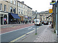
Devonshire Street
Looking towards Lowther Street.
Image: © Thomas Nugent
Taken: 22 Apr 2014
0.01 miles
2
Lloyds TSB, Carlisle
It is located at English Street
Image: © Kenneth Allen
Taken: 8 Oct 2009
0.01 miles
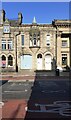
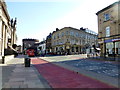
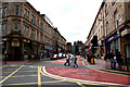
3
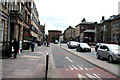
Carlisle: Lowther Street
Looking south from Bank Street and showing the segregated inbound bus lane.
Image: © Dr Neil Clifton
Taken: 6 Jul 2010
0.01 miles
4
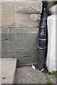
Benchmark on #10 Lowther Street previously Athe?um
Ordnance Survey cut mark benchmark described on the Bench Mark Database at http://www.bench-marks.org.uk/bm38298
Image: © Roger Templeman
Taken: 12 Jun 2011
0.01 miles
5
Former "Gretna Tavern" - February 2018 (3)
OS Maps indicate this was once part of the "Gretna Tavern", and would have been included in the lot sold by the State Management Scheme in 1973. Now commercial premises and appears currently To Let.
For information on the "Gretna Tavern", see: Image] .
Image: © The Carlisle Kid
Taken: 25 Feb 2018
0.01 miles
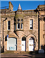
6
No. 10 Lowther Street
There is an Ordnance Survey benchmark Image on the front of the building at its right hand corner, left of a black downpipe
Image: © Roger Templeman
Taken: 21 Jul 2021
0.01 miles
7
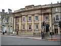
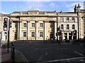
Lloyds Bank, Carlisle
Today this building on Lowther Street is a branch of Lloyds Bank, however, this building has a varied and interesting history. This Grade II listed building was the former post office. On the 12 July 1916 it opened as `The Gretna Tavern' the first State Managed pub in Carlisle. With a a nine-mile long cordite factory at nearby Gretna, excessive alcohol consumption became a problem and to counter this the British Government began nationalising pubs in an effort to control alcohol consumption; it began in the Carlisle and Siloth area and was known as the 'Carlisle Experiment'. In later years the pub underwent several name changes, including `The Shambles' in 1970s and 'The Post Public House' in the 1980s.
Historic England description
GV II Former Post Office, later a public house. 1863 for Her Majesty's Office of Works by J Williams of London; 1899 additions. Calciferous sandstone ashlar on chamfered painted plinth with part quoin bands/panelled pilasters; string course, cornice and solid parapet. Roof hidden by parapet; red brick ridge and end chimney stacks. 3 storeys, 3 bays extending back in open plan. Left double panelled doors and overlight; 3 casement windows with panelled aprons; overall sign board supported by stone pilasters dividing each window and door. First-floor round-arched sash windows in stone architraves and panelled aprons; 2nd-floor windows with eared surrounds and aprons with roundel.
INTERIOR completely refurbished in Victorian style. HISTORY: the site of the Butchers' Arcade of 1844. Plans for this building are in Cumbria County Record Office dated 1863, Ca/E4/2821. For photograph of this when it was the Post Office see Perriam (1989). Carlisle Journal (1899) says that the additional storey was to be started in September to make it the same height as the adjoining Athenaeum. Became the first State Managed pub in Carlisle in 1916 as `The Gretna Tavern'; changed its name to `The Shambles' in 1970s and The Post Public House in the 1980s. (Perriam DR: Carlisle in Camera 2: 1989-: P.9; Carlisle Journal: 25 July 1899).
Source: https://www.historicengland.org.uk/listing/the-list/list-entry/1218057
See also: https://historicengland.org.uk/whats-new/first-world-war-home-front/what-we-already-know/land/state-control-of-pubs/
Image: © Philip Halling
Taken: 26 Aug 2008
0.02 miles
8
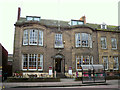
Club 35, Lowther Street (former Liberal Club)
Built in the 1830s as a private house (English Heritage listing http://list.english-heritage.org.uk/resultsingle.aspx?uid=1297408 ), the building was occupied by Carlisle Liberal Club from 1881 until 2008. Club 35 took over the premises shortly afterwards but closed in 2013, a couple of months after this photo was taken.
Image: © Rose and Trev Clough
Taken: 16 Jan 2013
0.02 miles
9
Lowther Street, Carlisle
Heading south
One of the twin towers at the Citadel can be seen in the background
Image: © Kenneth Allen
Taken: 19 Apr 2013
0.02 miles
10
Carlisle: Devonshire Street
Looking west from Lowther Street.
Image: © Dr Neil Clifton
Taken: 6 Jul 2010
0.02 miles