IMAGES TAKEN NEAR TO
Whiteclosegate, CARLISLE, CA3 0JA
Introduction
This page details the photographs taken nearby to Whiteclosegate, CA3 0JA by members of the Geograph project.
The Geograph project started in 2005 with the aim of publishing, organising and preserving representative images for every square kilometre of Great Britain, Ireland and the Isle of Man.

There are currently over 7.5m images from over14,400 individuals and you can help contribute to the project by visiting https://www.geograph.org.uk
Image Map
Images are licensed for reuse under creativecommons.org/licenses/by-sa/2.0
Notes
- Clicking on the map will re-center to the selected point.
- The higher the marker number, the further away the image location is from the centre of the postcode.
Image Listing (43 Images Found)
Images are licensed for reuse under creativecommons.org/licenses/by-sa/2.0
Image
Details
Distance
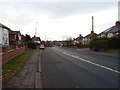
3
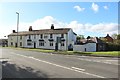
Whiteclosegate, Carlisle
Semi detached houses on Whiteclosegate on the eastern side of Carlisle.
Image: © Graham Robson
Taken: 6 Oct 2018
0.05 miles
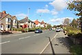
4
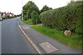
Looking NE along the B6264
There is a boundary stone Image on the grass verge in the right foreground
Image: © Roger Templeman
Taken: 16 Sep 2019
0.08 miles
5
The Near Boot, Tarraby - September 2016
A former "State Managed" pub, it is unclear when the Near Boot opened as it is not listed in an 1894 register. It came under State control in 1916 and did not return to private ownership until 10 May 1973, when it was sold to the John Smiths Brewing Group.
Photograph is for record only - I have no connection with this business and all queries should be directed through the web site: https://www.facebook.com/NearBoot/?ref=page_internal
Image: © The Carlisle Kid
Taken: 11 Sep 2016
0.08 miles
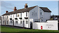
6
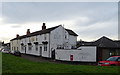
The Near Boot, Whiteclosegate
18th century Coaching Inn whose unusual name derives from the near-side boot when riding out of Carlisle. The Ordnance Survey cut a benchmark Image in January 1844 (1GL Survey) levelled at 98.166 feet above Liverpool Datum on a door jamb half way along the road face of the inn. A more recent mark Image was levelled at 30.02m above Newlyn Datum in 1972 at the NE end of the road face, by the black downpipe
Image: © Roger Templeman
Taken: 16 Sep 2019
0.09 miles
7
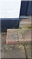
Remains of 1844 benchmark beside door of Near Boot Inn
The Ordnance Survey published abstract for the Carlisle to North Shields Survey of 1844/5 describes the benchmark as 'No. 8. Mark on jamb of door of the Old Boot Inn, at junction of roads ; 1.87 ft. above surface' levelled at 98.166 feet above Liverpool Datum
Image: © Luke Shaw
Taken: 16 Apr 2021
0.09 miles
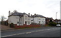
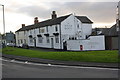
8
The Near Boot, Brampton Road, Carlisle
Presumably there is a Far Boot somewhere.
Image: © Christine Johnstone
Taken: 2 Nov 2015
0.09 miles
9
The Near Boot, Whiteclosegate, Carlisle
An unusually named pub, the Near Boot, on the eastern edge of Carlisle.
Image: © Graham Robson
Taken: 6 Oct 2018
0.10 miles
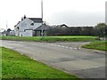
10
The Near Boot, Carlisle
On Whiteclosegate.
Showing position of Postbox No. CA3 93.
See Image] for postbox.
Image: © JThomas
Taken: 20 Nov 2019
0.10 miles