IMAGES TAKEN NEAR TO
Wakefield Road, CARLISLE, CA3 0HE
Introduction
This page details the photographs taken nearby to Wakefield Road, CA3 0HE by members of the Geograph project.
The Geograph project started in 2005 with the aim of publishing, organising and preserving representative images for every square kilometre of Great Britain, Ireland and the Isle of Man.

There are currently over 7.5m images from over14,400 individuals and you can help contribute to the project by visiting https://www.geograph.org.uk
Image Map
Images are licensed for reuse under creativecommons.org/licenses/by-sa/2.0
Notes
- Clicking on the map will re-center to the selected point.
- The higher the marker number, the further away the image location is from the centre of the postcode.
Image Listing (36 Images Found)
Images are licensed for reuse under creativecommons.org/licenses/by-sa/2.0
Image
Details
Distance
1
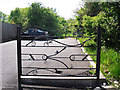
Decorative gate, Kingstown Wildlife Pond
It is a short walk from this car park at the southern end of Wakefield Road to a secluded pond Image .
Image: © Rose and Trev Clough
Taken: 26 May 2013
0.04 miles
2
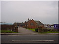
St Peter's Church, Kingsmoor
Next to a retail Park...
Image: © Bob Jenkins
Taken: 13 Jan 2006
0.06 miles
3
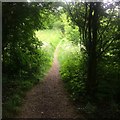
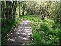
Canopy Footpath
One of the hidden footpaths that riddle Kingmoor woods
Image: © David Liddle
Taken: 19 Jun 2015
0.06 miles
4
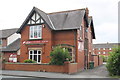
St Peter's Church
The Church of St John with St Peter, Kingmoor http://www.hkchurch.org.uk/about-us/ .
Image: © David Dixon
Taken: 5 Aug 2016
0.07 miles
5
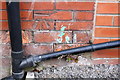
Benchmark on #213 Kingstown Road
Ordnance Survey cut mark benchmark described on the Bench Mark Database at http://www.bench-marks.org.uk/bm69407
Image: © Roger Templeman
Taken: 18 Jul 2015
0.09 miles
6
#213 Kingstown Road
There is an OS benchmark Image on the side of this vets practice right of the black downpipe
Image: © Roger Templeman
Taken: 18 Jul 2015
0.09 miles
7
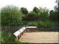
Boardwalk on path to Kingstown Pond
A small nature reserve with trees, bushes and marsh surrounds Kingstown Wildlife Pond.
Image: © Rose and Trev Clough
Taken: 26 May 2013
0.10 miles
8
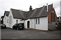
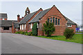
St Peter's School, Kingstown Road
Now houses a supplier of gas and electric fires and fireplaces. There is probably an Ordnance Survey flush bracket benchmark (see http://www.bench-marks.org.uk/bm10282 for details) on the brick face of the building behind the wooden lean-to.
Image: © Roger Templeman
Taken: 18 Jul 2015
0.11 miles
9
Kingmoor Wildlife Pond
Kingmoor Wildlife Pond, part of the network of connecting nature reserves which include Kingmoor Woods, Kingmoor Sidings & Kingmoor Nature Reserve North.
Image: © Andy Connor
Taken: 21 May 2010
0.12 miles
10
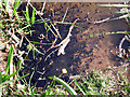
Tadpoles in Kingstown Wildlife Pond
The pond was teeming with them.
Image: © Rose and Trev Clough
Taken: 26 May 2013
0.13 miles