IMAGES TAKEN NEAR TO
St. Georges Terrace, WHITEHAVEN, CA28 6DE
Introduction
This page details the photographs taken nearby to St. Georges Terrace, CA28 6DE by members of the Geograph project.
The Geograph project started in 2005 with the aim of publishing, organising and preserving representative images for every square kilometre of Great Britain, Ireland and the Isle of Man.

There are currently over 7.5m images from over14,400 individuals and you can help contribute to the project by visiting https://www.geograph.org.uk
Image Map
Images are licensed for reuse under creativecommons.org/licenses/by-sa/2.0
Notes
- Clicking on the map will re-center to the selected point.
- The higher the marker number, the further away the image location is from the centre of the postcode.
Image Listing (90 Images Found)
Images are licensed for reuse under creativecommons.org/licenses/by-sa/2.0
Image
Details
Distance
1

Warning Notice, The Green, Bransty.
I was saddened to see this prohibitory notice while visiting this site about 200m from where I was born and grew up. As a lad in the 40's I was frequent witness to an impromptu football game in process here which I think had been going continually since about 1920, Sad that it has been deemed necessary to bring this to an official end.
Image: © Harold Potts
Taken: 10 Jun 2007
0.07 miles
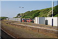
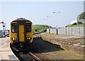
3
Carlisle train pulls into Whitehaven Station
Image: © N Chadwick
Taken: 29 May 2009
0.09 miles
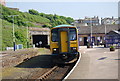
4
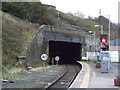
Platform 2, Whitehaven Station
Platform 2 at Whitehaven Station, formerly known as Whitehaven Bransty Station to distinguish it from Whitehaven Corkickle Station at the other end of Whitehaven Tunnel, the entrance of which is directly behind the photographer (see Image).
The 15 sign denotes a speed restriction of 15 miles per hour for down (northbound) trains through the sharply curved station platform.
Image: © Adrian Taylor
Taken: 21 Feb 2022
0.10 miles
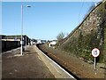
6
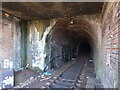
Whitehaven Tunnel
The north entrance of Whitehaven Tunnel; the end of the platform ramp of Platform 2 of Whitehaven Station (photograph Image) is visible in the right foreground (see also photographs Image and Image).
The small antenna visible at the crown of the brick arch is to permit two way communication with trains in the tunnel.
The England Coast Path and National Cycle Route 72 pass over the flat roofed section of the tunnel in the foreground.
Image: © Adrian Taylor
Taken: 21 Feb 2022
0.10 miles
7
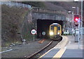
Whitehaven Railway Station
Northern Class 156, No. 156423 appearing from the tunnel.
Image: © JThomas
Taken: 23 Nov 2019
0.10 miles
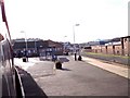
8
The Preston train pulls into Whitehaven Station
Image: © N Chadwick
Taken: 29 May 2009
0.11 miles
9

Whitehaven Railway Station
Northern Class 156, No. 156423.
Image: © JThomas
Taken: 23 Nov 2019
0.11 miles
10
Northern portal, Whitehaven Tunnel
Goes under Whitehaven town centre.
Image: © JThomas
Taken: 7 Nov 2012
0.11 miles