IMAGES TAKEN NEAR TO
William Pitt Industrial Estate, WHITEHAVEN, CA28 6AU
Introduction
This page details the photographs taken nearby to William Pitt Industrial Estate, CA28 6AU by members of the Geograph project.
The Geograph project started in 2005 with the aim of publishing, organising and preserving representative images for every square kilometre of Great Britain, Ireland and the Isle of Man.

There are currently over 7.5m images from over14,400 individuals and you can help contribute to the project by visiting https://www.geograph.org.uk
Image Map (Loading...)


Getting Data...Please wait
Leaflet Map data © OpenStreetMap
Images are licensed for reuse under creativecommons.org/licenses/by-sa/2.0
Notes
- Clicking on the map will re-center to the selected point.
- The higher the marker number, the further away the image location is from the centre of the postcode.
Image Listing (41 Images Found)
Images are licensed for reuse under creativecommons.org/licenses/by-sa/2.0
Image
Details
Distance
1
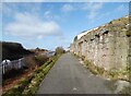
England Coast Path
At this point the England Coast Path follows a minor road that runs along land previously occupied by railway tracks serving William Pit. The substantial stone abutment supported a bridge over the Cumbrian Coast Line (originally the Whitehaven Junction Railway) which carried a tubway and a standard gauge railway track leading from William Pit to a spoil heap on the sea shore.
The Cumbrian Coast Line runs between the metal palisade fences.
Image: © Adrian Taylor
Taken: 21 Feb 2022
0.02 miles
2
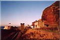
Redness Point, Whitehaven
This photo was taken near sunset, and the lighting suggests how the name of the cliff might have originated. The lane is part of the England Coast Path and is also the National Cycle Network Route 72.
Image: © Humphrey Bolton
Taken: Unknown
0.06 miles
3
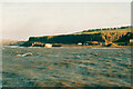
Redness Point
Accessed by a short walk from Whitehaven Harbour, this view near Redness Point also takes in a backdrop of the Kirkcudbrightshire hills across the Solway Firth.
Image: © James T M Towill
Taken: 19 Jul 2015
0.09 miles
4
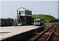
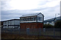
Signals and Signalbox, Whitehaven
The remains of a once extensive system
Image: © Jonathan Thacker
Taken: 17 Nov 2009
0.09 miles
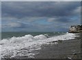
5
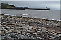
Cliffs at Redness Point, Whitehaven
I think this was taken from the North Pier lighthouse, but possibly from the West Pier Lighthouse. The quarry on the right was captioned 'Old Quarry' on the 1899 map, but not shown at all on the first edition, c.1870. '
Image: © Humphrey Bolton
Taken: Unknown
0.10 miles
6
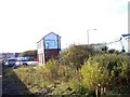
North Beach at Bransty
Taken below the railway embankment, looking back towards Whitehaven harbour entrance.
Image: © David Martin
Taken: 13 Apr 2015
0.12 miles
9
Bransty Signal Box
On the Cumbrian Coast Line near Whitehaven.
Image: © JThomas
Taken: 23 Nov 2019
0.14 miles
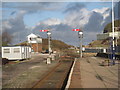
10
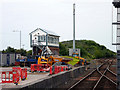
Bransty Signal Box
Viewed here from the northern end of Whitehaven Station.
Image: © John Lucas
Taken: 25 Jun 2013
0.15 miles