IMAGES TAKEN NEAR TO
Wood Street, CARLISLE, CA2 7JF
Introduction
This page details the photographs taken nearby to Wood Street, CA2 7JF by members of the Geograph project.
The Geograph project started in 2005 with the aim of publishing, organising and preserving representative images for every square kilometre of Great Britain, Ireland and the Isle of Man.

There are currently over 7.5m images from over14,400 individuals and you can help contribute to the project by visiting https://www.geograph.org.uk
Image Map
Images are licensed for reuse under creativecommons.org/licenses/by-sa/2.0
Notes
- Clicking on the map will re-center to the selected point.
- The higher the marker number, the further away the image location is from the centre of the postcode.
Image Listing (58 Images Found)
Images are licensed for reuse under creativecommons.org/licenses/by-sa/2.0
Image
Details
Distance
1
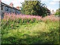
Overgrown bowling green
Situated between Bright Street (left) and Wood Street, off Newtown Road.
The site is owned by Carlisle City Council - looks like it's been neglected for years.
Image: © Rose and Trev Clough
Taken: 27 Aug 2016
0.03 miles
2
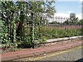
Gate to abandoned bowling green, Bright Street
For information see Image .
Image: © Rose and Trev Clough
Taken: 27 Aug 2016
0.03 miles
3
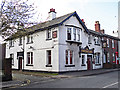
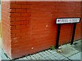
The Pedestrian Arms
On Newtown Road, at the corner of Bright Street.
The Pedestrian Arms was listed in street directories from 1869. Its name was changed to the North British Railway Inn around 1877, and back to the Pedestrian Arms in 1916, when the State Management Scheme took over control of Carlisle pubs (see 'Carlisle Breweries and Public Houses 1894-1916' by S. Davidson http://www.bookscumbria.com/cgi-bin/trolleyed_public.cgi?action=showprod_2274 ).
The pub closed a few months after this photo was taken, and was demolished in 2014.
See also Image .
Image: © Rose and Trev Clough
Taken: 17 Apr 2012
0.04 miles
4
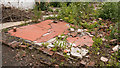
Site of "Pedestrian Arms" pub, Newtown Road - June 2017 (4)
Tile at the back of the former pub - possibly from a kitchen or toilet area.
For information on the pub, see: Image] .
Image: © The Carlisle Kid
Taken: 25 Jun 2017
0.05 miles
5
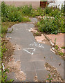
Site of "Pedestrian Arms" pub, Newtown Road - June 2017 (3)
Little remains of the former "Pedestrian Arms" - period photographs suggest these tiles leading away from Newtown Road may have been at the pub entrance.
For information on the pub, see: Image] .
Image: © The Carlisle Kid
Taken: 25 Jun 2017
0.05 miles
6
Site of "Pedestrian Arms" pub, Newtown Road - June 2017 (2)
A view of the site looking into Bright Street.
For information on the pub, see: Image] .
Image: © The Carlisle Kid
Taken: 25 Jun 2017
0.05 miles
7
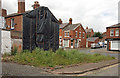
Site of "Pedestrian Arms" pub, Newtown Road - June 2017 (1)
The "Pedestrian Arms" dated from the building of New Town Place (now simply part of Newtown Road) between 1842 and 1848, although the first record of a "beerhouse" on the site does not appear until 1861. Around 1877 the name was changed to "North British Railway Inn" as the North British Railway had its shed and yards not far away. Acquired by the State Management Scheme on 7 September 1916, the name was changed back to "Pedestrian Arms" - possibly to discourage use by off-duty railway staff.
Sold by the Scheme to Greenall Whitley on 22 May 1973, the pub closed in 2012 and was demolished in 2015. Views of the demolition may be seen: http://ablogfrommydog.com/contents1a/2015/05/pedestrian-arms-pub-in-carlisle-demolished/
Rose & Trev Clough photographed the pub in 2012 and their view can be seen: Image
See also: Image], Image] and Image
Image: © The Carlisle Kid
Taken: 25 Jun 2017
0.05 miles
8
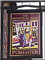
Pub sign - The Pedestrian Arms
Belonged to a pub on Newtown Road which was demolished in 2014 - see Image .
Image: © Rose and Trev Clough
Taken: 17 Apr 2012
0.05 miles
9
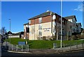
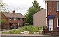
Kingston Court Care Home
Located on Carlisle's Newtown Road near the Infirmary.
Image: © Mary and Angus Hogg
Taken: 31 Jan 2015
0.05 miles
10
Benchmark on Lucky Chop Suey House
Ordnance Survey cut mark benchmark on side of Chinese take-away. The mark is described in more detail on the Bench Mark Database at http://www.bench-marks.org.uk/bm34890
Image: © Roger Templeman
Taken: 17 Jul 2010
0.05 miles