IMAGES TAKEN NEAR TO
Head Street, CARLISLE, CA2 7BQ
Introduction
This page details the photographs taken nearby to Head Street, CA2 7BQ by members of the Geograph project.
The Geograph project started in 2005 with the aim of publishing, organising and preserving representative images for every square kilometre of Great Britain, Ireland and the Isle of Man.

There are currently over 7.5m images from over14,400 individuals and you can help contribute to the project by visiting https://www.geograph.org.uk
Image Map
Images are licensed for reuse under creativecommons.org/licenses/by-sa/2.0
Notes
- Clicking on the map will re-center to the selected point.
- The higher the marker number, the further away the image location is from the centre of the postcode.
Image Listing (106 Images Found)
Images are licensed for reuse under creativecommons.org/licenses/by-sa/2.0
Image
Details
Distance
1
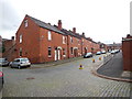
Carlisle - Head Street
Old red brick terrace houses viewed from Canal Street.
Image: © James Emmans
Taken: 12 Sep 2016
0.01 miles
2
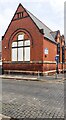
Caldew Lea Primary School at Ashley Street / Head Street junction
There is an Ordnance Survey benchmark Image on the near corner, left hand face, of the school
Image: © Roger Templeman
Taken: 12 Jul 2021
0.03 miles
3

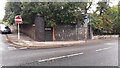
Abutment of dismantled railway bridge
At the junction of Canal Street (left) and Wigton Road. The line here opened in 1837, as a goods extension from the Newcastle and Carlisle Railway's London Road depot to the Carlisle Canal basin. The bridge was rebuilt at least twice, following a collapse in 1875 and for road widening in the 1920s (see Cumberland News article 27.03.2009 http://www.cumberlandnews.co.uk/features/christmas/The-night-a-goods-train-took-the-plunge-0c1a8180-67ae-474c-b75c-f036b20090da-ds ). It ceased to be used after the Waverley Line closed in 1969, and was demolished in 1974.
See also Image .
Image: © Rose and Trev Clough
Taken: 24 Sep 2013
0.03 miles
4
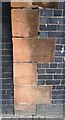
Quoins of former bridge of dismantled railway on NW side of Wigton Road
Ordnance Survey documents indicate that a benchmark levelled at 63.827 feet above Liverpool Datum was cut 4.14 feet above surface here during the 1843/4 Kirkby Kendal to Carlisle 1GL Survey. The mark appears to have eroded away. The surveyor's description was 'No. 385. Mark on North-west pier of Caldew-gate Railway Bridge'
Image: © Roger Templeman
Taken: 2 Oct 2021
0.03 miles
5
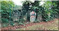
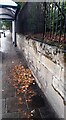
Old headstones in former churchyard
There are quite a number of headstones, fenced off along the wall. For location, see Image .
Burials in the churchyard ceased more than 100 years ago, it was laid out as open space around 1930 (Cumberland News http://www.cumberlandnews.co.uk/news/plaque-will-mark-site-of-former-carlisle-church-1.860881?referrerPath=home/2.3080 ). The site is now a park with sports and play facilities.
The building behind the wall is Caldew Lea Primary School.
Image: © Rose and Trev Clough
Taken: 8 Sep 2011
0.03 miles
6
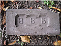
Brick from old railway bridge?
This was lying about a metre away from Image . Comparing it with other people's photos, on Flickr http://www.flickr.com/photos/nottsexminer/8175252535/ and 'Old Bricks' website http://www.penmorfa.com/bricks/england4.html , it was probably made by the Bull Bridge Brick Co in Derbyshire. We couldn't find any information about when this brickworks was operating.
Image: © Rose and Trev Clough
Taken: 24 Sep 2013
0.04 miles
7
Remains of bridge of dismantle railway at junction of Wigton Road and Canal Street
There used to be an Ordnance Survey benchmark on the left hand bridge pier Image The other side of the bridge on SE side of Wigton Road is at Image
Image: © Roger Templeman
Taken: 2 Oct 2021
0.04 miles
8
Gravestones from former Holy Trinity Church churchyard stored by boundary wall
Image: © Roger Templeman
Taken: 2 Oct 2021
0.04 miles
9
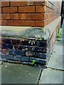
Benchmark on School
Ordnance Survey cut mark benchmark on school. The mark is described on the Bench Mark Database at http://www.bench-marks.org.uk/bm30957.
Image: © Roger Templeman
Taken: 17 Jul 2010
0.04 miles
10
Wall and bus shelter on NW side of Wigton Road opposite Silloth Street
There is what appears to be an Ordnance Survey benchmark Image on the wall's third stone above the pavement near the right edge of the image
Image: © Roger Templeman
Taken: 2 Oct 2021
0.04 miles