IMAGES TAKEN NEAR TO
Holme Terrace, Milbourne Street, CARLISLE, CA2 5XE
Introduction
This page details the photographs taken nearby to Holme Terrace, Milbourne Street, CA2 5XE by members of the Geograph project.
The Geograph project started in 2005 with the aim of publishing, organising and preserving representative images for every square kilometre of Great Britain, Ireland and the Isle of Man.

There are currently over 7.5m images from over14,400 individuals and you can help contribute to the project by visiting https://www.geograph.org.uk
Image Map
Images are licensed for reuse under creativecommons.org/licenses/by-sa/2.0
Notes
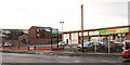
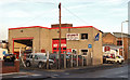
- Clicking on the map will re-center to the selected point.
- The higher the marker number, the further away the image location is from the centre of the postcode.
Image Listing (804 Images Found)
Images are licensed for reuse under creativecommons.org/licenses/by-sa/2.0
Image
Details
Distance
1
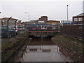
Millrace water
An off shoot to supply the old mills from the Caldew at Holmehead and then back into the Caldew at the Sheepmount.
Image: © David Liddle
Taken: 14 Jan 2009
0.02 miles
2
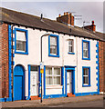
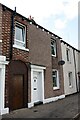
Former "Spinners Arms", Milbourne Street - March 2018
First recorded in the local directory of 1858 and is probably mid-19th Century, the "Spinners Arms" was acquired by the State Management Scheme on 29 August 1916. The Carlisle Family History web site (http://carlisleshistory.co.uk/ ) indicates it was closed in 1917 and has been a private dwelling since.
Image: © The Carlisle Kid
Taken: 28 Mar 2018
0.03 miles
4
Shaddongate Business Park, Carlisle
Image: © Alexander P Kapp
Taken: 24 Feb 2008
0.06 miles
5
No. 132 Melbourne Street
Ordnance Survey records indicate that a benchmark was levelled at 14.539m above Newlyn Datum on the concrete skirt of the house left of its door
Image: © Roger Templeman
Taken: 19 Aug 2019
0.06 miles
6
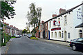
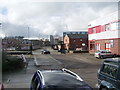
Milbourne Street and the Knight Inn (2008)
The Knight Inn closed in 2007, and has since been converted to residential use.
The pub was called 'The Woolpack' for about 120 years, renamed 'Biddy Mulligans' in 1997 and 'The Knight Inn' in 2003.
Information from http://www.closedpubs.co.uk/cumberland/carlisle_knightinn.html .
Image: © Rose and Trev Clough
Taken: 28 Sep 2008
0.06 miles
7
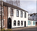
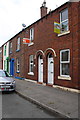
Former "Woolpack Inn", Milbourne Street - March 2018 (1)
First mentioned in the local directory for 1876, old photographs show it was very similar in appearance to the "Spinners Arms" (see: Image] ). It was acquired by the State Management Scheme on 3 August 1916 and was sold to the sitting tenant in 1973 for £6,920. Local records show it was given a "face lift" in 1977 with an extension added in 1988 (possibly the low building to the right). It was renamed "Biddy Mulligan" in 1997, but then banned Irish music in 1998 - which drove customers away! It came under new management on 28 March 2003 when renamed "Knight Inn", but closed on 9 July 2004 due to illness.
Now a private dwelling with no public access.
See also: Image] .
Image: © The Carlisle Kid
Taken: 28 Mar 2018
0.06 miles
8
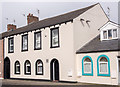
Former "Woolpack Inn", Milbourne Street - March 2018 (2)
For information on this building, see: Image] .
Image: © The Carlisle Kid
Taken: 28 Mar 2018
0.06 miles
9
Site of "Lorne Arms" - December 2016
Situated on the corner of Broadguards and Shaddongate (just to the right in this shot, where the cars are parked), the pub dated to circa 1837 when it was known as the "Weaver's Arms". Acquired by the State in August 1916 it was closed in 1919 and demolished in 1968.
Photograph is for record only - I have no connection with any business seen in this view and cannot advise on their products or services.
Image: © The Carlisle Kid
Taken: 5 Dec 2016
0.08 miles
10
Site of "Angler's Arms Inn" - December 2016
Little seems to be known of the "Angler's Arms", which was situated on the corner of Rigg Street and Shaddongate and was closed by the State Management Scheme on 12 October 1916. Although some of the small streets off Shaddongate have vanished, this is thought to be the pub's approximate location.
Photograph is for record only - I have no connection with any business seen in this view and cannot advise on their products or services.
Image: © The Carlisle Kid
Taken: 5 Dec 2016
0.08 miles