IMAGES TAKEN NEAR TO
East Vale Court, East Dale Street, CARLISLE, CA2 5JR
Introduction
This page details the photographs taken nearby to East Vale Court, East Dale Street, CA2 5JR by members of the Geograph project.
The Geograph project started in 2005 with the aim of publishing, organising and preserving representative images for every square kilometre of Great Britain, Ireland and the Isle of Man.

There are currently over 7.5m images from over14,400 individuals and you can help contribute to the project by visiting https://www.geograph.org.uk
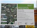
Image Map (Loading...)


Getting Data...Please wait
Leaflet Map data © OpenStreetMap
Images are licensed for reuse under creativecommons.org/licenses/by-sa/2.0
Notes
- Clicking on the map will re-center to the selected point.
- The higher the marker number, the further away the image location is from the centre of the postcode.
Image Listing (98 Images Found)
Images are licensed for reuse under creativecommons.org/licenses/by-sa/2.0
Image
Details
Distance
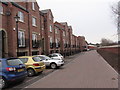
1
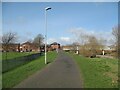
The Caldew Cycleway
The Caldew Cycleway is also the route of The Cumbria Way long distance path (next photograph Image).
The Robert Ferguson Primary School playing fields are on the left.
Image: © Adrian Taylor
Taken: 11 Mar 2019
0.02 miles
3
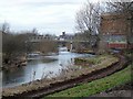
South Vale footbridge and River Caldew
Zoomed-in view from Bousteads Grassing. This is Image seen from a different angle. Opened in February 2009, it is stronger and higher than the old bridge, which was replaced as part of the Caldew flood alleviation scheme http://www.geograph.org.uk/photo/1197298 . Carlisle Cathedral can be seen in the distance.
Image: © Rose and Trev Clough
Taken: 21 Feb 2009
0.04 miles
4
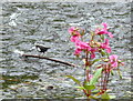
A dipper (Cinclus cinclus) on River Caldew
Image: © Roger Templeman
Taken: 7 Aug 2011
0.05 miles
6
Board explaining Caldew flood alleviation scheme
This is by the fence to Image Carlisle suffered severe flooding in January 2005 http://news.bbc.co.uk/1/hi/in_depth/photo_gallery/4159523.stm . Since then, a great deal of engineering work has been carried out to prevent it happening again.
Image: © Rose and Trev Clough
Taken: 21 Feb 2009
0.07 miles
7
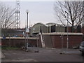
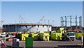
Household Waste Recycling Centre, Bousteads Grassing
Previously known as The Tip. In the hut a man with a stripy leg keeps watch, to make sure no trade waste enters the site. Ordinary householders who wish to transport their rubbish in a van or trailer, or on foot, must obtain a permit. Carlisle residents are currently sending more than 50% of household waste for recycling, mainly by kerbside collection.
Image: © Rose and Trev Clough
Taken: 18 Mar 2008
0.07 miles
8
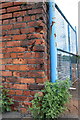
Benchmark on Rome Street wall
Ordnance Survey cut mark benchmark described on the Bench Mark Database at http://www.bench-marks.org.uk/bm27590
Image: © Roger Templeman
Taken: 26 Jun 2011
0.08 miles
9
Art Gallery, Carlisle
It is located along Castle Street
Image: © Kenneth Allen
Taken: 8 Oct 2009
0.08 miles
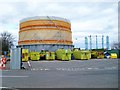
10
Carlisle Gas Works - March 2018
No longer producing gas, but now the site of a recycling centre.
Image: © The Carlisle Kid
Taken: 26 Mar 2018
0.08 miles